NASA eyes another developing depression in northern Indian Ocean

The Northern Indian Ocean typhoon season usually lasts until the end of December, but it's not going out without a fight this year. Infrared satellite data from NASA's Aqua satellite showed bands of thunderstorms wrapping around low pressure System 92B's center. If this system develops it would become Tropical Depression 06B.
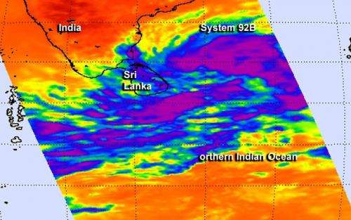
NASA's Aqua satellite passed over the low pressure area designated as System 92B on Dec. 5 at 07:59 UTC/2:59 a.m. EST and the Atmospheric Infrared Sounder or AIRS instrument captured infrared data about the developing storm. AIRS data showed a large area of strong convection and high, cold thunderstorm cloud tops north and east of the center of circulation.
At the time of the AIRS image, the western-most edge of the low covered most of the island nation of Sri Lanka where it brought rain. AIRS data showed bands of thunderstorms also wrapping into the center from the west and south. The circulation appears to be consolidating today, December 5.
At 1500 UTC/10 a.m. EDT on December 5, System 92B as centered near 9.8 north and 84. 0 east, about 293 nautical miles southeast of Chennai, India. Winds in the area were estimated to be 25 to 30 knots/28.7 to 34.5 mph/46.3 to 55.5 kph. Satellite data indicated that the strongest winds were in the northern half of the low. The low pressure area is moving north-northeastward at 6 knots/6.9 mph/11.1 kph.
The low-level center of the system lies to the south of a subtropical ridge (elongated area) of high pressure, which is providing good outflow, but is also causing vertical wind shear, which is inhibiting the development.
The Joint Typhoon Warning Center expects this low pressure area to become a tropical depression and curve away from India. It is expected to move in a northeasterly direction toward the center of the Bay of Bengal.
Provided by NASA's Goddard Space Flight Center


