New NASA animations show massive rainfall totals from 2013 Philippine Tropical Cyclones

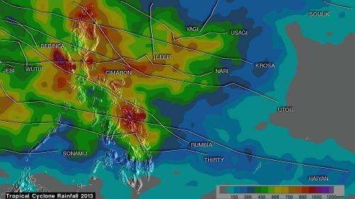
Rainfall data from the TRMM satellite was compiled and analyzed for tropical cyclones affecting the Philippines in 2013 and made into a movie. Satellite data showed that almost four feet of rain fell in parts of the northern and central Philippines.
In a normal year percent of the total rainfall near the Philippines, located in the Western Pacific Ocean is caused by tropical cyclones. The Tropical Rainfall Measuring Mission satellite known as TRMM has the ability to measure rainfall from space, and it was working overtime in covering all of the rainfall from tropical cyclones that affected the Philippines in 2013.
A TRMM-based, near-real time Multi-satellite Precipitation Analysis (TMPA) was conducted at the NASA Goddard Space Flight Center in Greenbelt, Md. The TMPA was used to analyze only rainfall near tropical cyclones passing close to or over the Philippines in 2013. The TMPA analysis showed the estimated total rainfall contributed by named tropical cyclones this year.
The movie runs from January through November 11, 2013, and provides a color scale for rainfall from zero to 44 inches/1,100 mm. As the animation progresses, small icons with the names of each tropical cyclone that moved through the area are depicted in their tracks.
Almost all of the Philippines, with the exception of the far south, received between 16 inches and 32 inches of rainfall. The heaviest rainfall totals from tropical cyclones were found in locations where more than one tropical cyclone passed near the same location.
The most notable tropical cyclone this year was deadly Super Typhoon Haiyan that devastated the central Philippines in November 2013. Super Typhoon Haiyan, Tropical Depression 30W and Typhoon Rumbia passed over the central Philippines resulting in rainfall totals of over 1,100mm/~43 inches being estimated over the island of Leyte. At least seven tropical cyclones affected the northern Philippines resulting in rainfall totals greater than 1,200 mm/~47 inches near Luzon's western coast.
Provided by NASA's Goddard Space Flight Center


