Latest storm updates NASA satellites see Cyclone 03A make landfall in Somalia Tropical Cyclone 03A

In addition to the fierce winds and powerful surge, Haiyan brought copious amounts of rainfall to the central Philippines along with Tropical Storm 30W and another tropical disturbance (90w), which all passed through the the central Philippines within in the past ten days. The combined rainfall from these tropical cyclones is shown in the TRMM-based, near-real time Multi-satellite Precipitation data (TMPA) analysis shown above during the period from November 2-12, 2013 (first image to the right). It shows that most of the island of Leyte had rainfall totals greater than 500mm (~19.7 inches, dark red) with a peak amount of over 685 mm (~27 inches, lighter purple) located over the southeast corner of the island.
Peak and average rainfall over the central Philippines (second image to the right) shows that despite being far less intense, Tropical Storm Thirty, which preceded Super Typhoon Haiyan by about three days, produced similar peak rain intensities (shown in red) and over a similar duration, but less average rainfall (shown in blue) than Haiyan.
The remnants of what was once Tropical Storm Thirty (30W) over the Philippines have made there way into the Bay of Bengal after dropping heavy rainfall over Indochina.
Tropical Depression 30W (Thirty) is now poised to bring rainfall to parts of India.

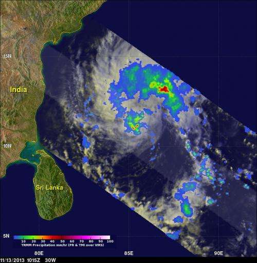
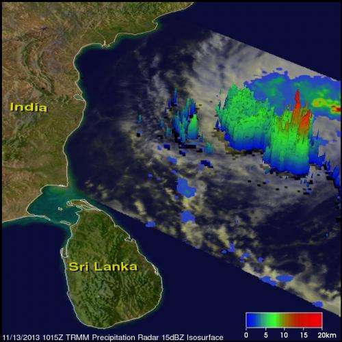
The image on the left shows a TRMM satellite view of rainfall with the newly energized tropical disturbance in the Bay of Bengal on November 13, 2013 at 10:15 UTC. TRMM's Microwave Imager (TMI) and Precipitation Radar (PR) instruments found rain falling at a rate of over 81 mm/hr (~3.2 inches) in convective storms at 11.0N 85.2W near the center of the tropical disturbance. The image on the right shows a 3-D view of 30W using data from TRMM's Precipitation Radar (PR) instrument. TRMM's PR found that a few of the powerful convective storms near the center of the tropical depression were reaching heights of 15.5 km (~9.6 miles).
TRMM is a joint mission between NASA and the Japanese space agency JAXA.
Provided by NASA's Goddard Space Flight Center


