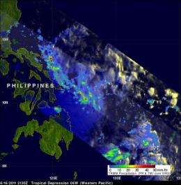
NASA satellite sees Tropical Depression 06W near the Philippines

The sixth western Pacific tropical cyclone (06W) of 2011 has developed near the Philippines and the Tropical Rainfall Measuring Mission (TRMM) satellite saw some heavy rainfall in the storm. Tropical Depression 06W was dropping the heaviest rain over the open waters of the Western North Pacific Ocean on June 17 as the storm continues to move toward China.
The TRMM satellite is operated by the Japanese Space Agency and NASA, and continually monitors the tropics and measures rainfall in tropical cyclones. TRMM captured an early morning look at the forming depression on June 16, 2011 at 2130 UTC (5:30 p.m. EDT). A precipitation analysis from TRMM's Microwave Imager (TMI) and Precipitation Radar (PR) showed that Tropical Depression 06W wasn't well organized but contained areas of moderate to heavy rainfall located east of the Philippines.
The heaviest rainfall appears on the northwestern and southeastern areas of the depression. Most of the rainfall is moderate falling at a rate between .78 to 1.57 inches (20 and 40 mm) per hour. The isolated areas of heavy rain over ocean areas are falling at about 2 inches (50 mm) per hour.
The Philippines have already received a lot of rain from tropical cyclones this season. Tropical storm Aere, Super Typhoon Songda and Tropical Storm Sarika have already affected the Philippines this year.
Now, Tropical Depression 06W threatens even more rainfall. On June 17 at 1500 UTC (11 a.m. EDT) Tropical Depression 06W had maximum sustained winds near 25 knots. It was located about 430 nautical miles east-southeast of Manila, Philippines near 12.1 North and 127.6 East. It was moving to the northwest near 13 knots.
Tropical Depression 06W is expected to intensify to a tropical storm, skirt the eastern coast of the Philippines and head toward Taiwan over the next five days. During the middle part of the week of June 19, Tropical Depression 06W is expected to make landfall in southeastern China.
Provided by NASA's Goddard Space Flight Center


