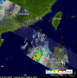
NASA sees heavy rainfall in Tropical Storm Sarika

Tropical Depression 05W has grown into a tropical storm and given the name Sarika as it heads toward China. Satellite imagery from NASA shows that the center of the storm seems to be separated from the strongest thunderstorms.
The Tropical Rainfall Measuring Mission (TRMM) satellite that is co-managed by NASA and the Japanese Space Agency measures rainfall in the tropics, and today's satellite imagery (June 10, 2011) on Tropical Storm Sarika shows that the heaviest rainfall (falling at 2 inches/50 mm per hour) is south of the center of the storm's circulation. That's an indication that the storm will not intensify. Normally in intensifying storms the heaviest rainfall is around the center of circulation. TRMM imagery is created at NASA's Goddard Space Flight Center in Greenbelt, Md.
In addition, infrared satellite imagery revealed that the low-level circulation center is now fully exposed, which allows outside winds inside to weaken the circulation of the storm. As the system continues to track north, it is expected to run into stronger wind shear, which is expected to keep the storm from strengthening.
Regardless of intensification, Tropical Storm Sarika is in the South China Sea and charting a course for Hong Kong and China and both have posted warnings. Hong Kong posted a "Stand-by Signal 1" across the territory.
Although Sarika didn't intensify into a cyclone until today, it brought heavy rainfall and flooding in the northwestern Philippines. A weather observer named Adonis was in contact with NASA's Hurricane web page and noted that five people were reported killed from rapidly rising flood waters in Central Luzon. He noted that intermittent rainfall fell in Iloilo and Guimaras Island last night as the system pulled away to the north.
At 1500 UTC (11 a.m. EDT) Tropical Storm Sarika had maximum sustained winds near 35 knots (39 mph). It was located about 160 nautical miles east-southeast of Hong Kong, China near 21.9 North and 116.9 East. Sarika is moving north at 14 knots.
Sarika is forecast to intensify before making landfall and dissipate east of Hong Kong over the weekend.
Provided by NASA's Goddard Space Flight Center


