Study documents the enduring contaminant legacy of the California gold rush

An unintended legacy of California's gold rush, which began in 1848, endures today in the form of mercury-laden sediment. New research by Michael Singer, associate researcher at UC Santa Barbara's Earth Research Institute, shows that sediment-absorbed mercury is being transported by major floods from the Sierra Nevada mountains to Central Valley lowlands. The findings appear today in the Proceedings of the National Academy of Sciences (PNAS).
Contamination of food webs as a result of mercury-laden sediment, coupled with regional shifts in climate, poses a huge risk to the lowland ecosystems and to the human population as well because a lot of people eat fish from this system.
"This new study addresses a gap in the general theory of the evolution of toxic sediment emplaced by industrial mining, which enables anticipation, prediction and management of contamination to food webs," Singer said.
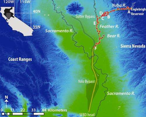
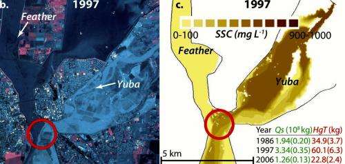
His research shows that mercury stored in immense Sierran man-made sediment deposits is carried by the Yuba River and other nearby streams to the Central Valley lowlands during 10-year flood events, most recently in 1986 and 1997. His team used several independent datasets and modeling of the episodic process to demonstrate how mercury-laden sediment stored in deep river valleys more than 150 years ago travels hundreds of miles into ecologically sensitive regions.
The discovery of this process was serendipitous. Singer and a colleague were working in California's Central Valley studying how quickly floodplains filled up with sediment when they came across Burma-Shave signs that said, "SAND."

"We thought that was quite strange because the floodplains around us were so much finer –– composed of silt and clay materials," recalled Singer. "So we followed the signs and ended up in a huge sand mine. They were mining sand by the truckload for the construction industry and said they would be doing so for at least the next several decades."
It turns out that a massive flood in 1986 in the Yuba River Basin brought enough sand with it to bury a major rice field, which a savvy farmer then leased to the sand-mining operator. According to Singer, the upstream Yuba was the biggest gold-mining drainage of all the Sierra drainages used in the 19th century, so it made sense to think about possible mercury contamination because gold rush miners used mercury to separate gold.
"They didn't just pan for gold," Singer said. "That's a romantic notion of gold mining. It was actually an industrial process whereby they sprayed giant high-pressure hoses, invented in 1852, at upland hillsides to wash the sediment downstream. Sides of mountains were washed away and sent downstream, and the sediment started filling in these confined river valleys, actually spreading all the way out to San Francisco Bay. This caused problems for steamboat operations and increased flooding on lowland farms. The U.S. government ultimately got involved and stopped the mining in 1884, which basically ended the gold rush overnight."
Singer says mercury is currently a big problem in San Francisco Bay and the Delta. "People know there was gold mining in the Sierra Nevada and they know that there was mercury mining in the Coast Ranges, but they're not really sure of the modern-day impact, especially when the contaminant sources are not directly by the bay," he said. "People want to know what is causing contamination of the food webs of the Central Valley."
The PNAS paper begins to answer that by documenting flood-driven fan erosion, sediment redistribution and a process called progradation, the growth of a sedimentary deposit farther out into the valley over time, which, in this case, spread the mercury-laden sediment into parts of the basin where there is higher risk of it being taken up by food webs.
The research team compared gold rush data with modern topographic datasets, which showed that the Yuba River was progressively cutting through the sediment and in the process leaving behind massive contaminated terraces along the riverbank. Flood data and modeling indicate that these terraces move only when a flood event is big enough to saturate them so that the terraces fail and the mercury-laden sediment is carried and driven downstream.
"There is a lot of sediment left in the system that is highly contaminated and readily available to be remobilized and sent downstream just because it's sitting in unconsolidated sediments along the margins of a river that can become very big during a storm," Singer said. "That susceptibility, coupled with projections for climate change in the region indicating more massive storms in the future, means that there is a dangerous synergy."
More information: Enduring legacy of a toxic fan via episodic redistribution of California gold mining debris, www.pnas.org/cgi/doi/10.1073/pnas.1302295110
Journal information: Proceedings of the National Academy of Sciences
Provided by University of California - Santa Barbara


