NASA image: Barry expected to dissipate rapidly after landfall

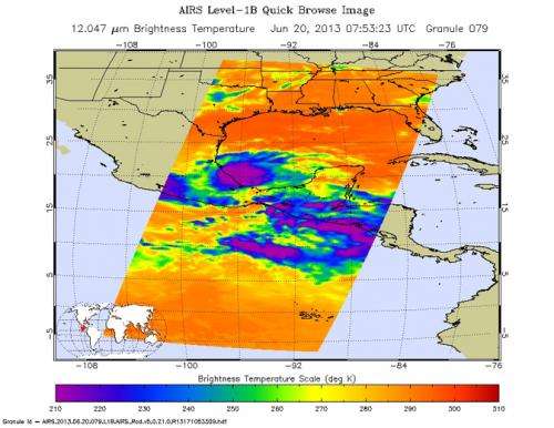
The Atmospheric Infrared Sounder (AIRS) instrument that flies aboard NASA's Aqua spacecraft captured this infrared image of Tropical Storm Barry in the Gulf of Mexico's Bay of Campeche at 07:53 UTC (3:53 a.m. EDT) on June 20, 2013, as the storm was about to make landfall in southern Mexico.
At the time, Barry had maximum sustained winds of 40 knots (46 miles per hour, or 74 kilometers per hour), gusting to 50 knots (58 miles per hour, or 93 kilometers per hour).
The AIRS image shows Barry's cloud top temperatures, with the coldest clouds and most powerful thunderstorms depicted in shades of purple.
The storm is expected to rapidly dissipate after making landfall. Rainfall totals of 3 to 5 inches (7.6 to 12.7 centimeters), locally up to 10 inches (25.4 centimeters) are possible in southern Mexico, along with life-threatening flash floods and mudslides.
Provided by NASA's Goddard Space Flight Center


