NASA finds Tropical Depression Yagi's strongest side, now waning

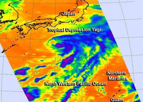
Infrared imagery from NASA's Aqua satellite on June 11 showed that Tropical Depression Yagi's strongest quadrant was east of its center. However, since them the storm has weakened after running into an upper-level low pressure area and cooler waters.
When NASA's Aqua satellite passed over Yagi on June 11 it was a tropical storm with strong thunderstorms on its eastern side. An infrared image of the storm was taken from the Atmospheric Infrared Sounder (AIRS) instrument aboard NASA's Aqua satellite on June 11 at 12:05 a.m. EDT. The areas with the coldest cloud top temperatures and strongest thunderstorms were near -63F/-52C around the center and indicative of heavy rainfall.
Since June 11, an upper-level low pressure area from the north of Yagi has moved closer to the storm's center, suppressing thunderstorm development. Animated infrared satellite imagery showed that the storm's low-level center is now fully exposed to outside winds and has elongated. Whenever a storm loses its circulation and becomes elongated it weakens (like a tire going flat that can't spin properly). There is no recognizable convection (rising air that forms thunderstorms that make up the tropical cyclone) around the storm's center.
In addition to the upper-level low squelching the storm, Yagi has moved into cooler waters that do not support maintaining a tropical cyclone. Sea surface temperatures of at least 80F (26.6 C) are needed to keep a tropical cyclone going. The sea surface temperatures around Yagi are as cool as 223 Celsius, too cool to maintain the storm.
On June 12 at 1500 UTC (11 a.m. EDT) Tropical depression Yagi was spinning down in the northwestern Pacific Ocean. Yagi's maximum sustained winds were down to 30 knots. It was centered near 31.2 north latitude and 138.9 east longitude, about 250 miles south of Yokosuka, Japan. Yagi is moving to the east-northeast at 8 knots.
According to the Joint Typhoon Warning Center (JTWC), the organization that forecasts storms in the northwestern Pacific, Yagi was still a "weakly symmetric warm-core system," but it is expected to become a cold-core low pressure area by the end of June 12. JTWC forecasters expect Yagi to dissipate by June 13.
Provided by NASA's Goddard Space Flight Center


