NASA satellites see changes in weakening Typhoon Mawar

NASA's Tropical Rainfall Measuring Mission (TRMM) and Aqua satellites are just two in NASA's fleet that have been providing data on the evolving and now devolving tropical cyclone. TRMM provided rainfall and other data, while the AIRS instrument on NASA's Aqua satellite provided cloud temperature and extent.
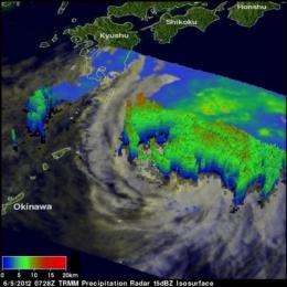
Typhoon Mawar was weakening when the TRMM satellite saw it during the daytime on June 5, 2012 at 0728 UTC (3:28 a.m. EDT/U.S.). Rainfall derived from TRMM's Microwave Imager (TMI) and Precipitation Radar (PR) instruments showed that Mawar was producing a very large area of rainfall southeast of Japan. Most of Mawar's heavy rainfall is revealed by TRMM to be north of the dissipating tropical cyclone's center. The most intense surface rainfall of over 40mm/hr (~1.6 inches) was shown northeast of the center. Much of Mawar's southwestern side was shown becoming rain free.

A 3-D image from TRMM's PR shows that Mawar no longer had an eye wall. Storms near Mawar's center of circulation were reaching to heights of only about 10km (~6.2 miles). The highest storm towers of over 11km (~6.8 miles) were located in a band far to the northwest of Mawar's center.
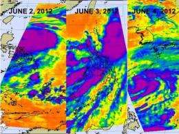
NASA's Aqua satellite flew over Typhoon Mawar and the Atmospheric Infrared Sounder (AIRS) instrument captured infrared images from the storm on June 4, 5, and 6 as it expanded, strengthened, rained on the Philippines and headed north in the western North Pacific. Strongest thunderstorms where high cloud top temperatures were colder than -63 Fahrenheit (-52 Celsius). AIRS data now shows that Mawar is now becoming extra-tropical and is interacting with a frontal zone located south of Japan.
At 0900 UTC (5 a.m. EDT) on June 6, Mawar's maximum sustained winds were down to 65 knots (75 mph/120.4 kph). It was located near 28.1 North and 133.5 East, about 110 nautical miles (126.6 miles/ 203.7 kph) north-northeast of Minamidaito, Japan. Mawar is moving northeast at 23 knots (26.4 mph/42.6 kph).
Mawar is expected to stay to the east of Japan and move between the big island and Chichi Jima and Iwo Two. It should continue tracking east-northeast while weakening.
The system is expected to complete extra-tropical transitioning sometime on June 6. It is expected to weaken because of wind shear increasing to greater than 40 knots (46 mph/84 kph) and cool sea surface temperatures, colder than 23 Celsius (73.4F). Sea surface temperatures of 26.6 C (80F) are needed to maintain a tropical cyclone. As Mawar continues moving east-northeast, Japan's big island will likely experience rough surf along east-facing shores.
Provided by NASA's Goddard Space Flight Center


