NASA sees Tropical Storm Sanvu continue to intensify

Two NASA satellites have provided infrared and rainfall data that has shown Tropical Storm Sanvu continues to intensify as it heads toward Iwo To, Japan. NASA's Tropical Rainfall Measuring Mission (TRMM) satellite has scanned rainfall rates, and NASA's Aqua satellite has provided a look at cloud temperatures which indicates where the strongest thunderstorms and heaviest rainfall is occurring.
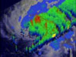
The TRMM satellite saw the intensifying storm on May 22, 2012 at 1535 UTC when wind speeds had reached to over 45 knots (~52 mph). Data from TRMM's Microwave Imager (TMI) and Precipitation Radar (PR) instruments show that Sanvu had a very large area of heavy rainfall wrapping around the northeastern side. TRMM's PR also shows that the highest convective storm towers, reaching to heights above 16km (~9.9 miles), were in a feeder band on the southeastern side.

On May 23, the TRMM passed over Sanvu again after it had strengthened further, and captured more data. That data was used to create another 3-D analysis at NASA's Goddard Space Flight Center in Greenbelt, Md. The 3-D image created from TRMM PR data revealed that an eye was almost formed indicating that Sanvu may soon be a typhoon. Several towers in the forming eye wall extend to heights above 16km (~9.94 miles). These towers contain the heaviest rains and act to energize the core of the storm.
On May 23 at 1500 UTC (11 a.m. EDT), Tropical Storm Sanvu has maximum sustained winds near 60 knots (69 mph/111 kph). It was located about 450 nautical miles south-southwest of Iwo To, Japan and moving toward the island in a northwesterly direction at 10 knots (11.5 mph/18.5 kph). Sanvu's center is near 17.8 North and 139.2 East.
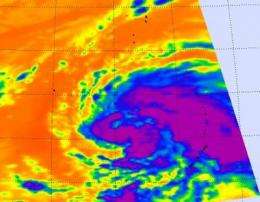
Infrared satellite imagery from NASA's Atmospheric Infrared Sounder (AIRS) instrument onboard NASA's Aqua satellite showed that Sanvu's feeder bands were mostly on the eastern side of the center of circulation and have become more tightly wrapped around the center. Those thunderstorms within the feeder bands have also strengthened. The strongest storms have a cloud top temperature colder than -63F (-52C) indicating they are high in the troposphere and powerful.
Sanvu is predicted to intensify further and become the first western Pacific typhoon of 2012. One factor that is helping Sanvu continue to intensify is the warm sea surface temperatures at 86 degrees Fahrenheit (30 Celsius).
The current forecast track takes it just east of Iwo To and Chichi Jima, which may experience typhoon conditions on May 25 and 26, respectively.
Provided by NASA's Goddard Space Flight Center


