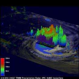
NASA's TRMM satellite sees Cyclone Jasmine in 3-D

Data from NASA's TRMM satellite was used to create a 3-Dimensional look at Cyclone Jasmine, currently moving through the South Pacific Ocean.
The Tropical Rainfall Measuring Mission (TRMM) satellite is managed by both NASA and the Japanese Space Agency. Using TRMM data, 3-D images of Cyclone Jasmine were created at NASA's Goddard Space Flight Center in Greenbelt, Md.
The TRMM satellite traveled directly above tropical cyclone Jasmine in the South Pacific Ocean on February 8, 2012 at 2156 UTC (4:56 p.m. EST). Jasmine was classified as a powerful category 4 on the Saffir Simpson Scale with wind speeds of 115 kts (~132 mph) at its peak intensity but had started to weaken at the time of this pass.
A 3-D image was created using data from TRMM's Precipitation Radar (PR). The 3-D cutaway image revealed the funnel shaped surface of Jasmine's eye. TRMM PR data also showed that heights of Jasmine's tallest storms then reached to heights of about 11.5 km (~7.1 miles).
Rainfall from TRMM's Microwave Imager (TMI) and Precipitation Radar (PR) instruments showed that intense thunderstorms in bands wrapping around Jasmine's large circular eye were dropping rain at a rate of over 50mm/hr (~2 inches). This was a daytime pass so the rainfall analysis was overlaid on a visible/infrared image from TRMM's Visible and InfraRed Scanner (VIRS) instrument.
Infrared imagery from instruments like the Atmospheric Infrared Sounder (AIRS) on NASA's Aqua satellite revealed that cloud top temperatures in Jasmine have been warming since early morning on February 9, 2012. That's an indication that the system is losing strength and the cloud tops are falling.
Jasmine is a small cyclone, only about 90 nautical miles (103.6 miles/166.7 km)in diameter, and the eye is about 20 nautical miles (23.2 miles/37 km) wide.
On February 9, 2012 at 0900 UTC, Jasmine's maximum sustained winds were near 105 knots (120.8 mph/194.5 kph). Jasmine was about 275 nautical miles (316.5 miles/509.3 km) east-southeast of Noumea, New Caledonia near 28.8 South and 171.4 East. Jasmine is moving to the south-southeast around 10 knots (11.5 mph/18.5 kph).
Jasmine is expected to move over cooler waters and encounter drier air, two factors that will further weaken the storm.
Provided by NASA's Goddard Space Flight Center


