Mapping the depths of the earth

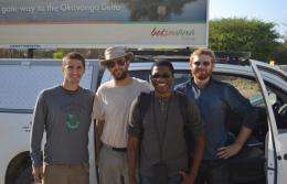
As they drove through the Okavengo Delta in Botswana, a team of Woods Hole Oceanographic Institute (WHOI) scientists and three Northeastern physics students encountered a wild elephant attempting to protect his home from the unlikely intruders.
Undeterred, the team ventured on to obtain a single GPS point along the East African Rift, which stretches between Kenya and Botswana and will eventually split the continent in two.
“It’s the fastest-moving fault in the world, so if you understand how it evolves over time it can give you a sense of how slower-moving faults are evolving,” said Mathew Chamberlain, who, along with fellow fourth-year students David Margolius and Colin Skinner, traveled to Africa and Hawaii to collect magnetotelluric data for their fall 2012 co-op.
Magnetotellurics (MT) is a method of deep-earth imaging that measures variations in the earth’s electromagnetic field caused by solar energy. Based on the conductivity of the material underground, these measurements help characterize what’s below, be it water, oil or lithosphere.
“We were using MT to image the fault in Botswana and Zambia, where the rifting is youngest. In Kenya, where the rift is older, you can literally see the rocks ripped apart,” Margolius said.
While data collection was the ultimate goal of the trip, generating that data was a rather laborious task: The students worked 12-hour days under a hot sun, digging trenches into which they deployed an MT data collector, 50-meter-long electrodes, coils that detect the magnetic field and a car battery to power the whole thing. A few days later, they’d return to dig it all up again.
After eight weeks in Africa, the students flew to Hawaii where they set out on a research vessel to collect MT data on the ocean floor of a remote part of the Pacific Ocean. In this case, the collected data would help WHOI estimate seismic activity across the globe.
Despite working and living alongside one another for six months, the students came away from the experiential-learning opportunity with three different goals for the future. Skinner said that working in Africa, where frequent blackouts made daily life difficult, reinforced the significance of the global energy crisis. “It has made me want to pursue research in new and extremely efficient renewable energy sources,” he said.
Chamberlain, on the other hand, is considering a graduate education in geophysics – a field he only came to know during this co-op. Margolius found the hands-on aspect of fieldwork rewarding. “In the future, I'd like to be involved in research that correlates to more practical applications,” he said.
Provided by Northeastern University


