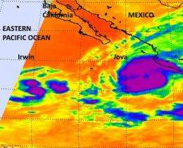
Spotty, strong convection seen in NASA imagery helps Irwin regain tropical storm status

Tropical Storm Irwin almost appeared down for the count, but spotty areas of flaring convection provided a clue to forecasters that he wasn't ready to give up yet. The cloud top temperatures were measured by a NASA instrument at a frigid -112 Fahrenheit, indicating they're very high and powerful.
An infrared image of Tropical Depression Irwin was taken from the Atmospheric Infrared Sounder (AIRS) instrument on NASA's Aqua satellite on Oct. 11 at 4:53 a.m. EDT. The infrared data revealed three areas of strong convection still occurring within the depression. Those three areas had high, very cold cloud tops (-80C/-112F) indicated strong convection, and heavy rainfall.
Irwin weakened to a tropical depression early today, Oct. 11, but by 11 a.m. EDT, was back to tropical storm status with maximum sustained winds near 40 mph (65 kmh). Those tropical storm- winds extend out 60 miles from the center, making Irwin a small tropical storm, only 120 miles in diameter.
Irwin is centered about 620 miles (1000 km) south-southwest the southern tip of Baja California, Mexico, near 15.3 North and 115.0 West. Irwin is moving to the east at 8 mph (12 kmh) and is expected to continue that direction today, but turn to the east-northeast on Oct. 12.
The National Hurricane Center discussion for Irwin's future indicates that the strengthening is only temporary because of stable air and increasing wind shear. If infrared data shows Irwin's cloud tops warming, that means they're falling and there's not as much energy in the atmosphere. If that happens, Irwin may drop to depression status again over the next couple of days.
Provided by NASA's Goddard Space Flight Center


