Taking the guesswork out of soil classification

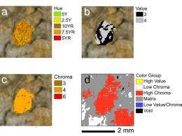
A University of Missouri doctoral student has developed a technique that uses digital imaging of soil samples to take some of the guesswork out of wetland identification.
Identifying wetlands isn't always easy. The U.S. Army Corps of Engineers' manual on wetlands identification is 143 pages long. Land that is wet isn't necessarily a wetland, and some wetlands aren't always wet. One important tool is looking at the soil for colors and patterns characteristic of frequent and prolonged saturation, said Kevin O'Donnell, a doctoral student in soil science at MU.
Chronic saturation changes a soil's structure and chemical composition and affects the types of microorganisms it harbors. These changes determine the colors and other visible features of soil. Soil scientists use those features to identify what they call "hydric soils."
A trusty companion of soil scientists in the field is a small loose-leaf binder holding a set of "Munsell Soil Color Charts," which contains 238 color chips and other visual aides for classifying soils.
There's a small hole adjacent to each chip that lets you compare the color chip and soil sample side-by-side.
"There's a lot of room for error," O'Donnell said. Cloud cover, time of day and many other factors can affect perception of a soil's appearance. Experienced soil scientists learn to take this into account, but even seasoned pros might come to different conclusions about a given sample.
"You're dealing with jurisdictional identification of wetlands," he said. "Imagine you're a landowner and a soil scientist comes out and says you have a hydric soil."
Wetlands are protected under the federal law, so landowners can end up facing restrictions on developing or farming their land based on a subjective assessment of the soil. "Will that hold up in court? I saw some major issues there."
In an earlier project, O'Donnell used software to analyze aerial photos of large areas and determine land use based on color and other attributes. "Why not use that technology on a smaller scale?"
He decided to bring soil samples to the laboratory and photograph them under controlled conditions.
For advice on photo equipment, O'Donnell sought out David Rees, chair of photojournalism at MU. O'Donnell procured a Nikon D80 camera, a 60mm f/2.8 macro lens and a pair of lens-mounted flashes to provide uniform, consistent lighting. His equipment purchases were funded in part by a scholarship named in honor of the late C.E. Marshall, an MU soil scientist and, as it turned out, the father-in-law of David Rees.
O'Donnell calibrated the software by photographing a brand-new set of Munsell color charts.
"I didn't know if this was going to work," O'Donnell recalled. The goal was to precisely quantify a soil sample's dominant colors in terms of hue, chroma (saturation) and value (lightness or darkness), as well as the abundance and distribution of those colors.
"It turns out that it works really well," he said. "The color identification was approximately 99 percent accurate for all the colors in the book."
Not only does the technique provide a more reliable way to identify hydric soils, it opens an avenue for collaboration with other disciplines by producing data about soil in a standardized, quantitative form, he said.
"Once you get here it opens up a door to new ways of looking at soils that haven't been looked at in the past," he said.
"It is a pretty ingenious amalgamation of techniques and ideas that provides soil scientists with a new tool for the 21st century," said Keith Goyne, an MU soil scientist.
O'Donnell describes his project in a paper that appeared recently in "Geoderma," considered a top-tier journal by soil scientists. O'Donnell's co-authors on the paper were Goyne, Stephen Anderson and Randall Miles of MU, and Claire Baffaut and Kenneth Sudduth of the USDA Agricultural Research Service.
O'Donnell's research is funded by a grant from the USDA's Conservation Effects Assessment Project with partial support from the University of Missouri Research Council.
O'Donnell said that it should be possible to adapt his system for use in the field by attaching a box to the camera to block out natural light when photographing a soil sample. In certain instances, this would avoid the expense and burden of extracting hefty core samples and hauling them to the lab.
Provided by University of Missouri-Columbia


