NASA looks at rare Arabian Sea tropical cyclone in 3-D

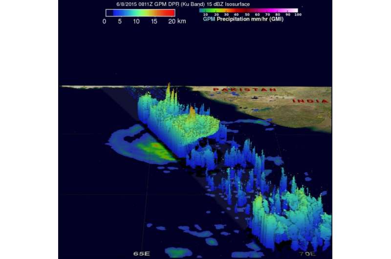
Tropical cyclones are not too common in the Arabian Sea, but tropical cyclone 01A, now renamed Ashobaa, formed this week. NASA/JAXA's Global Precipitation Measurement or GPM core satellite flew over Ashobaa and gathered data that provided a 3-D look at the rainfall in the storm.
The GPM core observatory satellite flew over Ashobaa on the morning of June 8 at 0811 UTC (4:11 a.m. EDT). Tropical cyclone Ashobaa had sustained wind speeds of about 40 knots (46 mph) when the satellite passed overhead.
On June 9 at 0900 UTC (5 a.m. EDT), tropical cyclone Ashobaa had maximum sustained winds near 50 knots (57.5 mph/92.6 kph). Ashobaa was centered near 20.7 north latitude and 64.1 east longitude, about 290 nautical miles (333.7 miles/ 537.1 km) south-southwest of Karachi, Pakistan. Ashobaa is moving west-northwest at 8 knots (9.2 mph/14.8 kph).
Satellite data on June 9 showed that the storm is tightly wrapped, although elongated as clouds and showers are being pushed to the west because of persistent moderate easterly wind shear.
The Joint Typhoon Warning Center (JTWC) predicts that tropical cyclone Ashobaa will become more powerful and have winds of 65 knots (about 75 mph) by June 10 as it moves through warm sea surface temperatures. Ashobaa is then predicted to weaken as dry stable air is expected to affect the system. It is forecast to turn west where it expected to make landfall on June 12 near Ras al Hadd, a village in the Ash Sharqiyah district in Oman.
As Ashobaa continues curving to the west in the Arabian Sea, it is generating rough surf along the coasts of Oman, southeastern Iran and Pakistan.
GPM's Microwave Imager (GMI) and Dual-Frequency Precipitation Radar (DPR) instruments measured rain falling at a rate of over 60 mm (2.3 inches) per hour in strong thunderstorms southwest of the storm's center of circulation.
Provided by NASA's Goddard Space Flight Center


