NASA sees no punch left in Tropical Storm Julio

Tropical Storm Julio doesn't have any strong thunderstorms or strong convection left in it according to infrared satellite imagery from NASA.
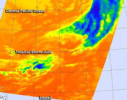
When NASA's Aqua satellite passed over Tropical Storm Julio on August 14 at 12:23 UTC (8:23 a.m. EDT), the Atmospheric Infrared Sounder known as AIRS analyzed the clouds and temperatures of the storm. The AIRS data showed that cloud tops had warmed and dropped lower in the atmosphere. That indicates that the strength behind rising air had weakened and was not forming strong, high thunderstorms with cold cloud tops.
There was a small area of cold cloud tops just southeast of the center of circulation where temperatures were near 230 kelvin (-43.1C/ -45.6F). That indicated the strongest storms in the tropical cyclone. Cloud top temperatures throughout the rest of the storm were warmer and weaker.
NOAA's Central Pacific Hurricane Center (CPHC) noted that the system remained devoid of strong convection (rising air that forms thunderstorms that make up a tropical cyclone) on August 15. That's because there was moderate vertical wind shear battering the storm, and Julio was continuing movement over increasingly cooler sea surface temperatures. Sea surface temperatures of at least 80F (26C) are needed to maintain the strength and Julio is moving north into temperatures below that threshold, which will continue to weaken it. CPHC noted that with no deep convection near the center to fuel the system, Julio is expected to continue weakening and lose its tropical characteristics.
Julio is so far from Hawaii and any land areas that there are no coastal watches or warnings in effect.
On August 15 at 0900 UTC (5 a.m. EDT) the center of Tropical Storm Julio was located near latitude 32.4 north and longitude 157.3 west, about 765 miles (1,235 km) north of Honolulu, Hawaii. Maximum sustained winds were near 45 mph (75 kph) but weakening. Julio is moving toward the north-northeast near 5 mph (7 kph). Julio is expected to turn toward the north, then toward the northeast over the next two days.
Julio is forecast to weaken to a tropical depression later on August 15, and a remnant low pressure areas before the day's end.
Provided by NASA's Goddard Space Flight Center


