New Svalbard avalanches revealed by satellite

Svalbard has experienced an unusually mild and rainy autumn and this has taken its toe on the vulnerable arctic Svalbard-nature.
Already in October, the weather triggered several avalanches and a single avalanche at the outskirts of Longyearbyen managed to destroy a road and led to several homes being evacuated.
However, the mild and rainy weather has continued.
Additionally, getting a clear picture of all the destruction is proving difficult because the Polar Night is making visibility limited.
High-tech satellites
Even though visibility is limited, new radar satellite images reveal several avalanches also in November.
They have so far not been detected because they haven't affected any settlements.
New and advanced radar satellites as Sentinel-1 from the European Union (The Copernicus Initiative) and ESA (European Space Agency) take pictures every 6th day and catch events on the ground despite the Polar Night or cloud cover – when optical satellites are "blind".
Researchers Bernd Etzelmüller and Andreas Max Kääb at the Department of Geosciences have examined these images.
"They reveal several avalanches all across Svalbard," says Etzelmüller.
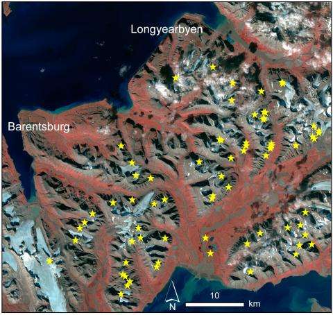
Kääb, the scientist responsible for processing the images, points to 50 avalanches in the area between Longyearbyen and Barentsburg alone.

Snow, slush and mud
Exactly what kind of avalanche we are talking about the images doesn't reveal.
"However, it's probably a mix of snow, slush and mud. It's nevertheless dramatic if it affects habited communities at Svalbard. Radar images works completely different than optical images and are sensitive to changes to humidity and ground structure," explains Kääb.
A selection of landslide locations marked with circles. Click to see an animation of radar footage before the landslides (6th of November) and after (12th of November).Further footage reveal that a majority of the landslides were triggered the 8th or 9th of November. Images: Copernicus/ESA.
The scientists are alarmed by the sheer number of avalanches in this period of heavy rain.
"It reveals that the system is currently out of joint. We know that the Svalbard eco-system is vulnerable and this is now definitely confirmed," they say.
Eztelmüller believes that data like this will be important to prepare for similar events of extreme weather in the future.
"It is very likely that extreme weather like this will be more common in the future. This will demand another level of emergency preparedness than what is currently in place, especially close to habited communities," he points out.
Reduced government funds
As part of this emergency preparedness Kääb explains how important it is that scientist get access to advances satellite images and to research initiatives that hold the key to the development of the technology behind the images.
As a result he is very upset on the back of the Norwegian 2017 State Budget were a cut of an unbelievable 75 percent in ESA Initiatives are proposed – they are the initiatives that directly funds earth observation analysis.
This work is supported by ESA through Glaciers_CCI and project GlobPermafrost, by the Norwegian Space Centre and their Copernicus program and by EU through ERC ICEMASS Initiative.
"Access to satellite images and development of high tech methods of analysis is crucial to reveal what effects extreme weather has on nature. Henceforth, it is now more important than ever that the authorities invest heavily in space technology," say Kääb and Etzelmüller.
Provided by University of Oslo


