Learning from past quakes

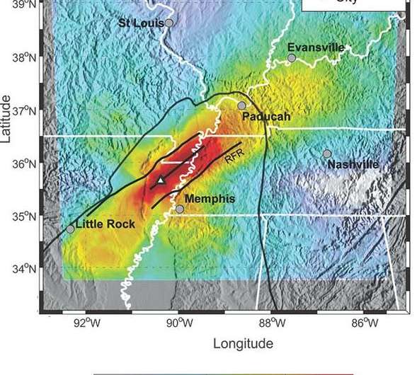
Computer simulations of ground shaking which replicates the historic, destructive 1811-1812 New Madrid seismic zone (NMSZ) earthquakes on the Tennessee-Missouri border suggest that future activity in the region could produce major, prolonged ground shaking. The findings could also have implications for our understanding of California earthquakes.
Scientists from San Diego State University, the U.S. Geological Survey, AECOM (formerly URS Corporation), and the University of Memphis simulated a set of 20 hypothetical yet plausible earthquakes located along two faults associated with current seismicity trends in the NMSZ. The hypothetical scenarios range in magnitude from 7.0 to 7.7 and consider various epicenters.
"Based on our simulations, more than 8 million people living and working near the New Madrid seismic zone would experience potentially damaging ground shaking with intensities ranging from VI to VIII if a repeat of the 1811–1812 earthquakes occurred today," said Leonardo Ramirez-Guzman, lead author of the paper that appears in the July 30 edition of the Bulletin of the Seismological Society of America.
"The duration of strong ground shaking in the greater Memphis metropolitan area could last from 30 to more than 60 seconds, depending on the magnitude and epicenter of a potential seismic event," said Ramirez-Guzman, former USGS scientist and current professor at Universidad Nacional Autónoma de México.
The simulations also demonstrate the importance of a geologic principle known as fault rupture directivity—when potential seismic energy piles up along the fault line—combined with the effects of seismic wave channeling along the northeast-southwest trending Reelfoot rift, a buried geologic valley in the NMSZ. In particular, simulating a strike-slip earthquake along the approximately 80-mile long southwest–northeast-striking NMSZ shows strong shaking at vibrational frequencies that spell trouble for mid-rise to high-rise buildings and tall bridges. For example, some of the earthquake models showed strong shaking focused northeast as far as 100 to 200 miles away near Paducah, Kentucky and Evansville, Indiana, and southwest 150 miles toward Little Rock, Arkansas.
Unfortunately, it is currently not possible to know which direction a fault will rupture once an earthquake starts. However, knowing there is an increased chance of strong shaking along these geologically-defined corridors could help officials develop plans to minimize their impact.
"This is also the case in our neck of the woods," said Kim Olsen, professor of geophysics in the SDSU geological sciences department, who contributed a set of earthquake computer simulations to the study. "While these simulations are getting closer to accurately predicting the shaking in a particular scenario, the possible range of shaking in a specific area is still large. The best advice is to be prepared for the stronger shaking and the resulting damage to the built environment by knowing what to do when the shaking begins."
Prepping for an earthquake includes making sure your bookshelves and heavy furniture are secured to the walls, Olsen said, and have a stash of potable water and food in an accessible location. If you feel shaking and you are indoors, get under a solid piece of furniture.
Journal information: Bulletin of the Seismological Society of America
Provided by San Diego State University


