TRMM satellite images show California soaker moved eastward

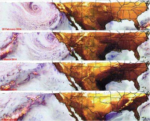
The Tropical Rainfall Measuring Mission or TRMM satellite provided a look at the rainfall associated with the large storm system that brought soaking rains to California on Feb. 28 and Mar. 1. Satellite imagery created at NASA shows the movement of the storm from the U.S. West Coast to the East Coast.
At NASA's Goddard Space Flight Center in Greenbelt, Md. images were created using data from the TRMM Microwave Imager (TMI) instrument that showed the movement of recent stormy weather from California's Pacific Ocean coast to the Atlantic Coast. TRMM is a satellite managed by both NASA and the Japan Aerospace Exploration Agency known as JAXA. Both agencies recently launched the GPM observatory, the follow-up to TRMM.
TRMM Images are routinely produced using TMI data which show the global area covered by the satellite. "Those 'quick look' images use microwave brightness temperatures at 85.5 GHZ and at 37.0 GHZ combined in the red, green and blue components of the images," said Hal Pierce of the NASA TRMM team at Goddard who produced the images. "The false color images can be used to distinguish land from water and show the differences between land surfaces such as deserts, snow cover and sea ice. On these images areas of dry atmosphere over water appear as blue and moist atmosphere is dark blue. Snow cover over land appears as white or grey, deserts are green. Scattering (by cloud ice) is shown as yellow."
The images Pierce created show TRMM Microwave Imager (TMI) views of the movement of the recent stormy weather from California's Pacific Ocean coast to the Atlantic Coast. The first TRMM TMI image from February 28 showed a large low pressure center in the Pacific Ocean moving toward California. Rain associated with this storm dropped over four inches of rain in Los Angeles that resulted in evacuation orders.
The next day, March 1, the center of the storm was just off the California coast and precipitation had also moved into Arizona. By Sunday, March 2, precipitation in the form of rain, freezing rain and snow extended from New Mexico through the Ohio valley. On Monday, March 3, TRMM's TMI instrument showed precipitation (yellow) and snow cover (white/yellow) over large areas of the eastern United States.
Provided by NASA's Goddard Space Flight Center


