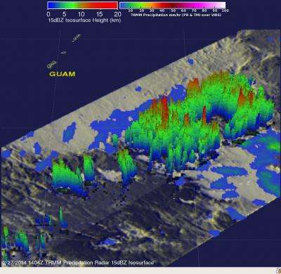
NASA saw rainfall rates increase before birth of Tropical Storm Faxai

The Tropical Rainfall Measuring Mission or TRMM satellite passed over System 93W in the Northwestern Pacific Ocean and saw rainfall rates increasing on February 27 in the developing tropical low pressure area. On February 28, the low organized and consolidated resulting in the birth of Tropical Storm Faxai.
The TRMM satellite, managed by both NASA and the Japan Aerospace Exploration Agency passed over System 93W on February 27, 2014 at 1404 UTC/9:04 a.m. EST. Tropical cyclone development southeast of the island of Guam looked more likely with this pass. An analysis of rainfall derived from TRMM Microwave Imager (TMI) and Precipitation Radar (PR) data was created at NASA's Goddard Space Flight Center in Greenbelt, Md. when the data was overlaid on an enhanced infrared image from TRMM's Visible and InfraRed Scanner (VIRS) instrument. The analysis revealed that the rates in which rain was falling had increase to 107 mm/~4.2 inches per hour in some convective storms.
TRMM PR data was used to create a 3-D perspective of the developing tropical low pressure area. The 3-D image showed that convective activity had increased and some towering thunderstorms in the area were reaching altitudes of up to 15.5km/~9.6 miles.
System 93W formed into Tropical Depression 03W early on February 28. By 1500 UTC/10 a.m. EST, the depression strengthened into a tropical storm and was renamed Faxai. At that time, Faxai's maximum sustained winds were near 35 knots/40 mph/62 kph. It was located near 9.0 north latitude and 149.0 east longitude, about 372 nautical miles/428.1 miles/688.9 km southeast of Andersen Air Force Base. Faxai is moving to the north-northeast at 3 knots/3.4 mph/5.5 kph.
The Joint Typhoon Warning Center forecast calls for Faxai to meander in the same area for a day before taking a northerly track. By March 3, Faxai is expected to intensify to hurricane- force over open waters of the Northwestern Pacific Ocean.
Provided by NASA's Goddard Space Flight Center


