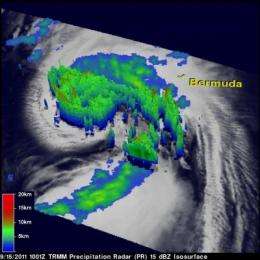
NASA sees power within hurricane Maria as it heads for a landfall in Newfoundland

Hurricane Maria joins twelve other hurricanes on record to make landfall in Newfoundland, Canada, and NASA satellite imagery revealed its inner strength.
The Tropical Rainfall Measuring Mission (TRMM) satellite passed over Hurricane Maria on Sept. 15 and the Precipitation Radar instrument revealed "hot towers," or towering cumulonimbus cumulus clouds that indicated a lot of strength in the storm. Hot towers penetrate the tropopause. They are called hot towers" because of the large amount of latent heat released as water vapor condenses into liquid and freezes into ice.
At NASA's Goddard Space Flight Center in Greenbelt, Md., Hal Pierce of the TRMM science team created a 3-D image from TRMM data. The 3-D image showed the hot towers around Maria's center had reached heights of over 11km (6.8 miles). It also showed powerful storms in feeder bands on Maria's western side were over 12km (7.5 miles) high, containing heavy rainfall (falling at 2 inches/50 mm per hour). Earlier NASA studies concluded that whenever hot towers are seen around the center of a tropical cyclone, the storm will likely intensify within six hours. In addition to that power within Maria, she's also moving very fast through the Atlantic which is helping keep her composure, according to the National Hurricane Center.
Another NASA satellite provided cloud temperatures, which relate to cloud height and strength. The Atmospheric Infrared Sounder (AIRS) instrument aboard NASA's Aqua satellite captured an infrared image that revealed strong convection (rapidly rising air that forms thunderstorms) and the strong thunderstorms around Maria's center, matching the TRMM satellite data. Those areas had cloud-top temperatures as cold as -63F/-52C. Cloud-top temperatures are important because they tell forecasters how high thunderstorms are, and the higher the thunderstorm, the colder the cloud tops and the more powerful the thunderstorms.
AIRS infrared image of Hurricane Maria was taken on Sept. 15 at 1:35 p.m. EDT and showed the long extent of Maria's clouds stretching from Florida to Nova Scotia, Canada. On Sept. 16, AIRS data showed the cloud top temperatures were warming, indicating that cloud heights are falling, and Maria had less energy (convection) than it did 24 hours before.
Since records have been kept in 1775, there have been 12 other recorded hurricanes to make landfall in Newfoundland. Tropical cyclones hit Newfoundland in 1775, 1866, 1873, 1886, 1891, 1893, 1939, 1958, 1995, 2000, 2002, and most recently, Hurricane Igor on Sept. 21, 2010. Igor struck Cape Race, Newfoundland as a category one hurricane with maximum sustained winds near 80 mph (120 kmh) and higher gusts. Igor was called the worst hurricane to hit Newfoundland in a century. Maria is the 13th storm to make landfall there.
Usually, Canada is hit with weak tropical cyclones because of the cool waters offshore. However, some storms have maintained hurricane strength because the warm waters of the Gulf Stream extend relatively close to eastern Canada.
Today, however, Maria is maintaining strength and has prompted a hurricane warning for Newfoundland from Arnolds Cove to Brigus south. A tropical storm warning is in effect for Newfoundland from Stones Cove to Arnolds Cove and from Brigus south to Charlottetown.
At 11 a.m. EDT, Hurricane Maria had maximum sustained winds near 75 mph (120 kmh). She was located about 210 miles (340 km) southwest of Cape Race, Newfoundland near 44.6 North and 56.3 West. Maria was speeding to the northeast at 52 mph (83 kmh) and had a minimum central pressure of 983 millibars. Tropical storm conditions are expected to continue across southeastern Newfoundland tonight, according to the National Hurricane Center. Hurricane conditions are expected by mid-day today. However, the National Hurricane Center noted that hurricane force winds are likely only occurring to the southeast of the center and could remain offshore if the center moves to the right of the forecast track.
Maria is already beginning to transition into an extra-tropical cyclone, and infrared imagery from NASA's AIRS instrument shows that all of the strong convection and strongest thunderstorms have moved north of the center.
Rainfall is expected to be between 1 and 3 inches, and coastal flooding is expected near and to the east of where Maria makes landfall. After passing Newfoundland, Maria will move into cooler waters and weaken over the weekend.
Provided by NASA's Goddard Space Flight Center


