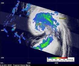
NASA's TRMM satellite reveals heaviest rainfall in Maria's northwestern quadrant

NASA's TRMM satellite peers through clouds and can decipher the rate rain is falling within a tropical cyclone, and data from the satellite shows that the heaviest rainfall is occurring in the northwestern quadrant of the storm, away from Bermuda.
The Tropical Rainfall Measuring Mission (TRMM) satellite traveled above tropical storm Maria on Thursday, September 15, 2011 at 1001 UTC ( 6:01 a.m. EDT). TRMM has the ability to measure rainfall rates and cloud heights, two factors that are important and helpful to the National Hurricane Center (NHC) meteorologists who are forecasting Maria's next move. The TRMM rainfall data that NASA provides to the NHC is helpful in determining the amount of rainfall that Bermuda will receive as Maria passes by. The NHC forecasts between 1 and 3 inches of rainfall for Bermuda today from Maria.
Maria's organization had improved over that seen by TRMM earlier in the week due to favorable (warmer) sea surface temperatures and lower upper level wind shear. A rainfall analysis from TRMM's Precipitation Radar (PR), displayed in a lighter swath, showed that powerful convective storms were dropping rainfall at a rate of over 50mm/hr (~2 inches) northwest of Maria's center of circulation. A large area of rainfall containing bands of heavier rainfall was also shown by TRMM's Microwave Imager (TMI) to be located between the storm's center and Bermuda. At the time TRMM passed over Maria, the NHC estimated that Maria had wind speeds of 55 knots (65 mph).
At 11 a.m. EDT on Sept. 15, Maria's maximum sustained winds were just shy of hurricane strength at 70 mph (110 kmh) and an eye appeared on microwave satellite imagery. Maria was about 130 miles west of Bermuda near 32.4 North and 67.0 West. Maria was speeding north-northeast at 30 mph (48 kmh) and had a minimum central pressure of 991 millibars. A Hurricane Watch and Tropical Storm Warning are currently in effect for Bermuda as Maria passes by today.
By 2:00 p.m. EDT today as Maria passes to the west of Bermuda, winds are predicted to reach minimal hurricane strength of 65 knots (75 mph). Maria is then forecast to turn to the northeast and speed up.
Provided by NASA's Goddard Space Flight Center


