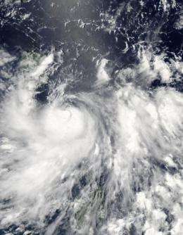
Tropical Storm Conson sweeping through the Northern Philippines

Tropical Storm Conson became a typhoon overnight with maximum sustained winds near 75 mph, and NASA's Aqua satellite captured an image of the storm as it was making landfall in Luzon, the Philippines. Conson is already moving into the South China Sea and headed for a landfall in south China.
The Moderate Resolution Imaging Spectroradiometer (MODIS) instrument aboard NASA's Aqua satellite captured a visible image of Typhoon Conson at 04:55 UTC (12:55 a.m. EDT/12:55 p.m. local Asia/Manila Time) on July 13, when it was moving over land in the northern Philippines. The interaction with land had an effect on Conson's winds, dropping them below typhoon-force. In the Philippines, Conson has been given the local name of "Basyang."
At 1500 UTC (11 a.m. EDT/11 p.m. local Asia/Manila time), Conson's winds had decreased to 60 knots (69 mph) after making landfall. Tropical-storm force winds extend as far as 65 miles from the center. Conson's center was about 70 miles east of Manila, near 14.5 North and 122.2. East and it was moving west at 14 knots (16 mph).
The following regional warnings are in effect in the Philippines: Public storm signal #3 is in effect for the following provinces of the Philippines: Aurora, Northern Quezon, Polilio Island and Camarines Norte. Public storm signal #2 is in effect for these provinces: Isabela, Nueva Viscaya, Nueva Ecija, Quirino, Bulacan, Rizal, Laguna, Southern Quezon, Marinduque, Camarines Sur, Catanduanes. Public storm signal #1 is in effect for: Cagayan, Kalinga, Mt. Province, Ilocos Sur, La Union, Benguet, Ifugao, Pangasinan, Tarlac, Zambales, Pampanga, Bataan, Cavite, Batangas, Albay and Metro Manila.
For updated, detailed forecasts from Philippine Atmospheric Geophysical and Astronomical Services Administration (PAGASA) on Tropical Storm Conson (Baysang), go to: http://www.pagasa.dost.gov.ph/wb/tc_up.html.
The Atmospheric Infrared Sounder (AIRS) Instrument that flies aboard NASA's Aqua satellite captured an infrared image of Tropical Storm Conson at 4:53 UTC (12:53 a.m. EDT) as it passed overhead from its orbit in space. The image showed strong convection and high, cold thunderstorm cloud tops. The image also showed that the northern Philippines were covered by the eastern half of the storm at that time, and its center was already moving into the South China Sea.
Tropical Storm Conson is forecast to continue weakening because of increased wind shear and interaction with the land surface of the northern Philippines. It will continue moving into the South China Sea and make a landfall in southern China.
Conson is the first tropical cyclone to reach hurricane strength in the northwest Pacific Ocean 2010 typhoon/hurricane season.
Provided by NASA's Goddard Space Flight Center


