The Philippines may finally get a break from Tropical Depression Parma

The Philippines can't seem to get rid of what is now a deadly and annoying Tropical Depression Parma, but forecasters are now providing hope.
Parma may have weakened into a tropical depression, but its still causing a lot of trouble for the residents of the Philippines today. Parma is again moving over Luzon and is expected to finally reach the South China Sea on Friday.
Warnings are still up for many areas of the Philippines again today. Public storm warning signal One is in force in Batanes Group of Islands, Cagayan, Babuyan Islands, Calayan Islands, Isabela, Ilocos Norte & Sur, Apayao, Abra, Kalinga, Ifugao, Mountain Province, Benguet, La Union, Pangasinan, Nueva Viscaya, Quirino, Aurora, Nueva Ecija, Tarlac, Pampanga, Zambales, Bataan and Bulacan.
Parma's center at 11 a.m. EDT today, October 8 was 145 miles north of Manila, near 17.1 North and 121.0 East. Parma had sustained winds near 35 mph and was moving west at 8 mph.

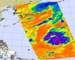
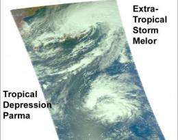
The Aqua satellite captured both Extra-Tropical Storm Melor over northwestern Japan, and Tropical Depression Parma still over the Philippines on October 8 at 0353 UTC (Oct. 7, 11:53 p.m. ET). The infrared image from Aqua's AIRS instrument showed some high, cold, thunderstorm cloud tops as cold as -63F still in Parma, but warmer and less powerful thunderstorms in Melor. Those higher, colder thunderstorms in Parma are areas where moderate to heavy rainfall is occurring.
Parma is expected to keep together until it finally moves over the South China Sea and may re-intensify once over open water.
In terms of the Philippines, Parma looks like the short-term end of this tragic, wet period for residents there. Even though a new tropical depression has formed north of Guam, it is forecast to head north then northeast and away from the Philippines.


