This article has been reviewed according to Science X's editorial process and policies. Editors have highlighted the following attributes while ensuring the content's credibility:
fact-checked
trusted source
proofread
How cities can use AI to adapt to climate change

Urban spaces are particularly susceptible to the effects of climate change, such as heat waves, floods, and storms. But which areas of a city are affected, and how can city planners respond?
I4C—Intelligence for Cities is an interdisciplinary project conducted by the University of Freiburg and several Fraunhofer Institutes. The researchers spent the last three and a half years developing models that enable precise and detailed measurements and predictions with the help of artificial intelligence (AI)—for example on the frequency of thermal stress, but also on the effects of changes in planning, such as planting trees or increasing the population density of a neighborhood.
The project also treated ethical issues in the use of AI and the importance of data protection. The results are published in Geoscientific Model Development.
Thermal stress in Freiburg
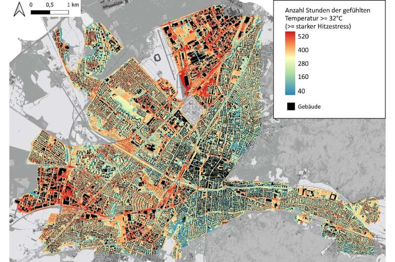
Among other things, the researchers developed an AI-based model capable of depicting thermal stress on a small scale and over several decades. This artificial neural network (ANN) was applied to the entire city of Freiburg on the basis of regional climate data and calculated the thermal stress in high resolution down to the level of individual streets. The team calculated thermal stress with the help of three independent physical models and verified the results using data from a network of measuring stations located throughout the metropolitan area.
"It was very interesting for us to see that what the network predicted was so close to reality, although the network does not explicitly model the underlying physical processes. Only in this way could we observe such large prediction spaces," says computer scientist Prof. Dr. Thomas Brox, professor for pattern recognition and image processing at the University of Freiburg and head of the project.
AI determines the position of trees
The model still needs to be merged with data on the vulnerability of individual urban spaces, but it can already be used now to evaluate urban planning measures such as the unsealing of surfaces. In addition, the researchers developed a novel method for automatically determining where to plant trees in a neighborhood to achieve the maximum reduction of thermal stress. The method uses a classic machine learning algorithm to optimize the position of the trees.
The researchers also developed an AI-based wind model and investigated, among other things, what impact local winds have on thermal stress in the urban environment. "For climate research, the AI methods developed in the project open up entirely new possibilities for depicting the effects of climate change right at your doorstep," says Prof. Dr. Andreas Christen, professor for environmental meteorology at the University of Freiburg.
Potential for practice
In a simulation as well as on the basis of interviews with representatives from various departments of Freiburg's city administration, the researchers also studied where the project's AI-based tools could actually be put to good use in urban planning, what opportunities, risks, and challenges this would involve, and how the tools should be further adapted for practical use.
"I see the great potential of AI tools above all in the fact that they can simulate the effects of various planning scenarios more quickly, for example on heat development. This means that various interactions can be better assessed and incorporated into the planning process at an early stage," says Verena Hilgers, the City of Freiburg's climate adaptation manager.
Usability and acceptance
Michael Bauder, head of the City of Freiburg's data science office, adds, "The challenge is to integrate such an artificial neural network into the city's existing IT and data structures, to make it easy to use for professional users, and to continually develop the system further with large amounts of data."
The project also addressed sociopolitical aspects, for example in two participatory ethics forums and other citizen participation activities. The first results of a survey among citizens in the Freiburg region already show differentiated attitudes towards AI applications in the public sector; opinions ranged from enthusiastic support to concerned skepticism.
More information: Ferdinand Briegel et al, High-resolution multi-scaling of outdoor human thermal comfort and its intra-urban variability based on machine learning, Geoscientific Model Development (2024). DOI: 10.5194/gmd-17-1667-2024
Provided by University of Freiburg


