This article has been reviewed according to Science X's editorial process and policies. Editors have highlighted the following attributes while ensuring the content's credibility:
fact-checked
peer-reviewed publication
trusted source
proofread
New geological map reveals secrets of Greenland's icy interior

A team of international scientists involving the Durham University Geography department has unveiled a new map of the geological provinces hidden beneath the Greenland Ice Sheet.
This comprehensive synthesis, published in Geophysical Research Letters, promises to advance our understanding of this critical component of the global climate system.
The new subglacial geology map provides an invaluable modernized framework for interpreting the solid Earth properties that shape the Greenland Ice Sheet's past, present, and future behavior.
Using a wealth of geophysical data, including seismic, gravity, magnetic, and topographic surveys, the researchers have meticulously delineated the boundaries of geological provinces across the island and, crucially, beneath the ice.
Revealing a complex and heterogeneous landscape
This updated map represents a significant advancement over previous efforts, which were hampered by limited data availability.
By combining diverse geophysical datasets, the researchers have been able to map Greenland's subsurface structure in unprecedented detail, revealing a far more complex picture than was previously known.
Notably, the team's findings show that north of 72°N, Greenland's geology is clearly more heterogeneous than previously thought.
There are also three distinct subglacial regions identified in central and northern Greenland whose unique geophysical signatures do not align with the island's marginal geology, suggesting the presence of as-yet-unknown geological provinces.
Implications for understanding Greenland's ice dynamics
The researchers also detected intriguing geophysical anomalies aligned with the onset regions of the Petermann Glacier and the Northeast Greenland Ice Stream, two of Greenland's most dynamic outlet glaciers.
This discovery points to a potential link between subglacial geology and ice sheet dynamics, a relationship that warrants deeper investigation.
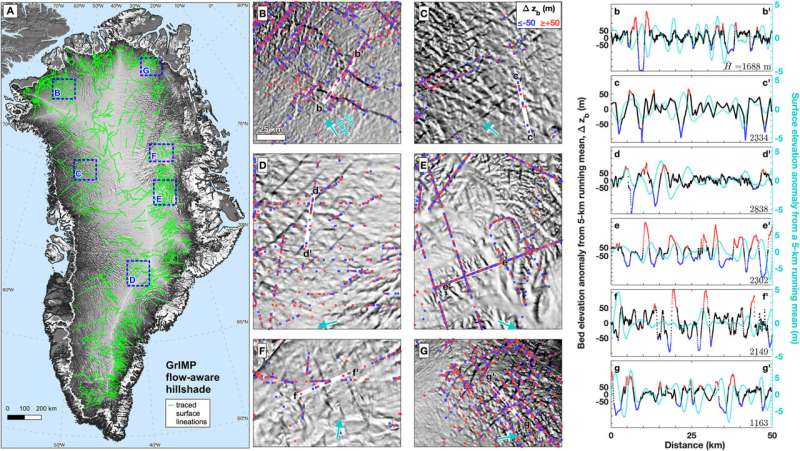
In addition, the team's analysis of surface topography data revealed an extensive network of remarkably long, straight, and parallel subglacial valleys crossing Greenland's interior.
These features, which remain poorly resolved in current topographic models, may hold clues about the island's tectonic history and could provide new avenues for investigating the ice sheet's past dynamics.
More information: Joseph A. MacGregor et al, Geologic Provinces Beneath the Greenland Ice Sheet Constrained by Geophysical Data Synthesis, Geophysical Research Letters (2024). DOI: 10.1029/2023GL107357
Journal information: Geophysical Research Letters
Provided by Durham University


