This article has been reviewed according to Science X's editorial process and policies. Editors have highlighted the following attributes while ensuring the content's credibility:
fact-checked
peer-reviewed publication
trusted source
proofread
An adaptive representation model to efficiently represent geoscience knowledge

A geoscience knowledge graph (GKG) is an effective way of organizing various geoscience knowledge into a machine-understandable and computable semantic network. However, existing knowledge graph representation models leverage fixed tuples that are limited in fully representing complex spatiotemporal features and relationships in geoscience knowledge.
To address these issues, a paper proposes an adaptive representation model of GKG considering the complex spatiotemporal features and relationships. The paper is published in the journal Science China Earth Sciences.
Under the constraint of a unified spatiotemporal ontology, this model can efficiently represent the complex spatiotemporal features and relationships in geoscience knowledge by automatically adopting an adaptive tuple structure, based on the association of spatiotemporal information. It can also provide effective and robust support to the unified construction, computation, and reasoning of interdisciplinary GKGs.
The paper first discusses the classification of geoscience knowledge. From the perspective of knowledge functionality, geoscience knowledge can be classified into conceptual knowledge, factual knowledge, rules, and metaknowledge. Conceptual knowledge contains fundamental concepts, as well as concepts used to describe entities/elements, phenomena, events, and scenes in geoscience.
Factual geoscience knowledge includes facts about real-world entities/elements, phenomena, events, and scenes in geoscience. Rule knowledge in geoscience refers to rules, computational models, theorems, and axioms. Metaknowledge records the personnel, time, and content information related to the creation and updates of the above three types of geoscience knowledge.
The paper presents the unified frameworks for spatiotemporal features and analyzes the relationships in geoscience knowledge.
The unified time framework of geoscience knowledge consists of three components: chronology, calendar, and timing. While the unified spatial framework of geoscience knowledge is composed of horizontal coordinates and vertical elevation based on a specific spatial reference system.
Relationships among geoscience knowledge can be divided into attribute relationships among attributes and concepts, instance relationships among instances and concepts, and association relationships among different concepts and instances.
Association relationships are mainly expressed through attributes of concepts, including semantic relationships, temporal relationships, spatial relationships, compositional relationships, functional relationships, and computational relationships. Temporal relationships, spatial relationships, and computational relationships are the key relationships that distinguish GKGs from general KGs.
-
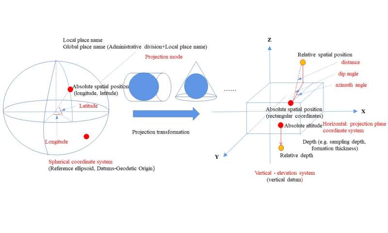
The unified spatial framework of geoscience knowledge is composed of horizontal coordinates and vertical elevation based on a specific spatial reference system. Credit: Science China Press -
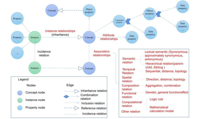
Relationships among geoscience knowledge can be divided into attribute relationships among attributes and concepts, instance relationships among instances and concepts, and association relationships among different concepts and instances. Association relationships are mainly expressed through attributes of concepts, including semantic relationships, temporal relationships, spatial relationships, compositional relationships, functional relationships, and computational relationships. Credit: Science China Press
Based on the classification of geoscience knowledge and the analysis of spatiotemporal features and relationships, an adaptive representation model for GKG based on spatiotemporal association is proposed. This model automatically chooses the most appropriate tuple to represent geoscience knowledge based on the spatiotemporal association.
Its basic idea is to first represent the content of geoscience knowledge using fundamental tuples and then automatically determine whether to separately represent temporal or spatial information based on the association of spatiotemporal features.
The representation of spatiotemporal information must refer to the unified spatiotemporal ontology to ensure accurate spatiotemporal computation and reasoning across different knowledge based on a consistent spatiotemporal reference and expression way. The creation and updating of geoscience knowledge can be recorded using metaknowledge, based on which the evolution analysis and traceability of geoscience knowledge can be achieved.
Using the adaptive representation model of GKGs, geoscience knowledge can be completely and accurately represented according to the spatiotemporal association, which refers to the level of closeness between geoscience knowledge and its spatiotemporal information.
It can be roughly divided into four categories:
- Weak spatiotemporal association. This refers to a situation where geoscience knowledge is weakly correlated or uncorrelated to spatiotemporal information, or minimally influenced and constrained by spatiotemporal conditions.
- Moderate spatiotemporal association. This refers to a situation where geoscience knowledge is relatively closely correlated to spatiotemporal information and has spatiotemporal attributes.
- Strong spatiotemporal association. This refers to a situation where geoscience knowledge has a very close correlation to spatiotemporal information which should be a core component of the knowledge. Once spatiotemporal information varies, the connotation of geoscience knowledge will change accordingly.
- Super-strong association. This refers to a situation where the knowledge is about temporal and spatial entities themselves. The spatiotemporal association can be computed using rule-based approaches or deep learning approaches.
More information: Yunqiang Zhu et al, An adaptive representation model for geoscience knowledge graphs considering complex spatiotemporal features and relationships, Science China Earth Sciences (2023). DOI: 10.1007/s11430-022-1169-9
Journal information: Science China Earth Sciences
Provided by Science China Press


