November 13, 2023 feature
This article has been reviewed according to Science X's editorial process and policies. Editors have highlighted the following attributes while ensuring the content's credibility:
fact-checked
trusted source
proofread
Plant health as a new effective monitoring system for volcanic activity

Plants have a symbiotic relationship with their surrounding environment, being a vital indicator of the overall health of the landscape, as well as significant changes within it. One such driver of plant response is gas emissions, such as those from volcanic activity, which elevate carbon dioxide and water emissions in the immediate area, consequently impacting leaf area and photosynthesis (the biological process through which organisms such as plants convert light energy into chemical energy using chlorophyll, producing sugars that are metabolized to fuel the organism's activities).
New research, published in Geochemistry, Geophysics, Geosystems, has investigated the link between carbon dioxide uptake by plants in response to elevated volcanic degassing, something which has previously been challenging to detect using satellites in space and to differentiate from normal atmospheric levels.
Robert Bogue, a Ph.D. researcher at McGill University, Montreal, Canada, and colleagues monitored plant responses to volcanic emissions in the Tern Lake thermal area of the Yellowstone Caldera, Wyoming, U.S., to determine their reaction to hydrothermal activity (circulating fluids in the vicinity of a magma source producing hot water and steam).
The research team used remotely-curated Landsat images from the United States Geological Survey across an area of ~33,000 m2, taken from satellites orbiting the Earth between 1984 and 2022, and compared plant health in the hydrothermal area with that in nearby forests unaffected by volcanic activity.
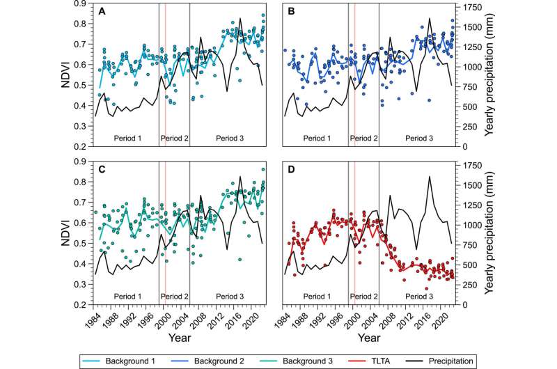
They used the Normalized Difference Vegetation Index (NDVI), a measure of chlorophyll abundance in a given area, which acts as a proxy for photosynthesis and therefore plant health. NDVI uses unitless values between -1 and 1, where healthy vegetation scores 0.6–1 and anything less healthy will have lower values.
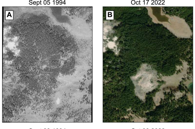
Bogue and colleagues found a steady increase in plant health through 1984–2000, which is attributed to fertilization of the ground by expulsion of carbon dioxide and magmatic water. However, a noticeable shift occurred in the early 2000s, with a deterioration in NDVI (plant health) and considerable mortality of trees (specifically lodgepole pine) within the hydrothermal area, especially in its epicenter.
This decreased NDVI expanded slowly between 2000 and 2005, but rapidly for the next decade up to 2015 when it stabilized, which is inferred as the expansion of the hydrothermal area.
Here, enhanced soil temperatures >50°C, detected by thermal infrared imaging, and extremely high carbon dioxide and sulfur emissions created an acid-sulfate zone, evidenced by smoking fumaroles and the distinctive rotten egg smell of hydrogen sulfide. Together, this caused extreme stress to the trees, something visible in the Landsat images before being detected by other satellites. Combined, they are also three key indicators of a shallow magma, and exacerbate further as the magma continues to rise with an imminent volcanic event.

The physical shift in vegetation health through the study period was also tracked by selecting locations within the Tern Lake thermal area that had the highest NDVI value each year, monitoring movement of the hydrothermal epicenter.
From 1985 to 1992, the lowest NDVI values (poorest plant health) occurred in the south of the area, yet from 1993 to 2001 this shifted to the north, then to the center of the region thereafter. It is at this point that a bare patch of dead trees has now become visible in the aerial imagery above. The researchers suggest the transition of the epicenter through the study period may result from the pathways for hydrothermal fluid migration becoming blocked over time due to mineral deposition from the magmatic waters, causing new routes to be sought.
Therefore, this research confirms hydrothermal activity began in the area 15 years earlier than had previously been reported, suggesting the noticeable shift in the early 2000s was a reawakening of volcanism, rather than the initial onset.
It is also supported by records of minor earthquake activity, which is often an indicator of magmatic fluid movement below ground. Such information highlights the benefit of this technique on providing a wealth of data that may otherwise be undetected by thermal infrared or visible imagery.
Recent fieldwork by the team has also found new tree growth within the barren area, suggesting that hydrothermal activity in the region may be waning and that a rebirth of vegetation may take place over subsequent years.
This research spotlights a new and valuable tool to measure the effects of volcanic activity in environments that may be challenging to access or particularly dangerous for in situ instruments, being especially suitable for stratovolcanoes whose flanks are often forested.
While it is useful as a precursory warning to supplement other forms of remote sensing to anticipate volcanic hazards, the technique is currently limited to locations with relatively homogenous vegetation species as this can impact NDVI values. It also poses challenges for areas prone to drought or wildfires, which are non-volcanic stresses that may skew results, while volcanic areas at high elevations or in arid zones may have sparse tree cover that inhibits NDVI measurements.
Nevertheless, the project offers an important method for monitoring volcanoes and the health of their surrounding environments to mitigate potential future hazards.
More information: Robert R. Bogue et al, Volcanic Diffuse Volatile Emissions Tracked by Plant Responses Detectable From Space, Geochemistry, Geophysics, Geosystems (2023). DOI: 10.1029/2023GC010938
© 2023 Science X Network


