September 26, 2023 report
This article has been reviewed according to Science X's editorial process and policies. Editors have highlighted the following attributes while ensuring the content's credibility:
fact-checked
trusted source
proofread
A newly refined map of Zealandia drawn using study of dredged rock samples

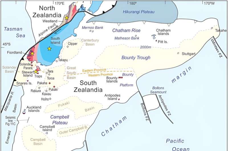
A small international team of geologists and seismologists has created a newly refined map of Zealandia using data obtained from dredged rock samples recovered from the ocean floor. They report details in the journal Tectonics.
Prior research has suggested that approximately 83 million years ago, the supercontinent Gondwana was pulled apart by geological forces, resulting in the beginnings of the continents that exist today. It also resulted in the creation of another continent that is now submerged. That continent, called Zealandia, is believed to be approximately 94% under the sea—the remaining 6% make up New Zealand and surrounding islands.
Because it is submerged beneath the ocean, Zealandia is not nearly as well studied as the conventional continents, resulting in inconsistencies in its presumed form and structure. In this new effort, the research team sought to refine existing maps of Zealandia by studying collections of rocks and sediment samples brought up from the ocean bed, most of which came from drilling sites—others came from the shores of islands in the area.
The team then studied the samples as part of a secondary study that involved analyzing seismic data for the region. They then created a more refined map of the whole 5 Mkm2 Zealandia continent.
Study of the rock samples showed geologic patterns in West Antarctica that hinted at the possibility of a subduction zone near the Campbell Plateau off the west coast of New Zealand. The researchers did not find magnetic anomalies in that area, however, which argues against theories surrounding a strike-slip in the Campbell Fault.
They suggest instead that the Campbell Magnetic Anomaly System resulted from stretching of Gondwana as it was being torn apart. That stretching, they further propose, eventually led to a break, which resulted in the creation of ocean floor that makes up the lower parts of the Zealandia continent.
The newly refined map shows not only the location of the magmatic arc axis of the Zealandia continent but other major geological features as well.
More information: Nick Mortimer et al, Reconnaissance basement geology and tectonics of North Zealandia, Tectonics (2023). DOI: 10.1029/2023TC007961
© 2023 Science X Network


