This article has been reviewed according to Science X's editorial process and policies. Editors have highlighted the following attributes while ensuring the content's credibility:
fact-checked
peer-reviewed publication
trusted source
proofread
First pixel-scale matching framework to quantify plant diversity and ecosystem services in Xishuangbanna

Biodiversity is the basis of ecosystem services, and the two are closely related. Earlier studies have assessed their relationship at the regional or watershed scale.
Researchers from Xishuangbanna Tropical Botanical Garden (XTBG) of the Chinese Academy of Sciences and their collaborators have pioneered a pixel-scale matching degree analysis framework to quantify endangered plant diversity and ecosystem services in Xishuangbanna. The study was published in Environmental Science and Pollution Research on Aug. 16.
By using the maximum entropy (MaxEnt) and Integrated Valuation of Ecosystem Services and Trade-offs (InVEST) models, the researchers created a spatial matching degree index of high-resolution with 30m × 30m pixel size. Using the framework, they modeled and depicted the spatial matching degree index of endangered plant diversity and ecosystem services in Xishuangbanna. The matching degree was classified into four types: low–low, low–high, high–low, and high–high.
They found that there was a mismatch relationship between the endangered plant diversity and ecosystem services in more than 70% of areas. Under the influence of altitude and land use/land cover type, the matching degree of endangered plant diversity and ecosystem services showed obvious spatial heterogeneity.
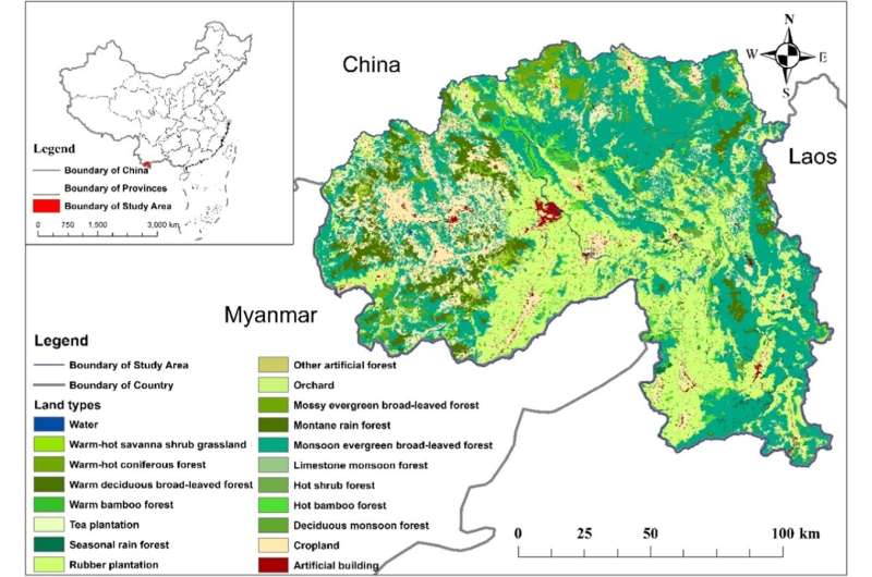
In low-altitude areas in the south of Xishuangbanna, endangered plant diversity and ecosystem services mainly showed mismatch, while high-altitude areas in the west had a better match. In natural forest, the main land cover, endangered plant diversity and ecosystem services showed high-high match and its areal proportion was much larger than that of rubber plantation, tea plantation, and cropland.
"Conservation priority should be given to the areas showing a low-low match between endangered plant diversity and ecosystem services, indicative of potential ecological vulnerability," said Bai Yang from XTBG, corresponding author of the study.
The researchers recommended that future research and policy making should consider both biodiversity and ecosystem services, along with the complex interactions between them.
"The pixel-scale spatial matching degree analysis framework developed in this study for endangered plant diversity and ecosystem services provides high-resolution maps with 30m × 30m pixel size, which can support the implementation of ecological protection measures and policy formulation, and has a wide range of applicability," said Bai.
More information: Fan Zhang et al, Spatial heterogeneity analysis of matching degree between endangered plant diversity and ecosystem services in Xishuangbanna, Environmental Science and Pollution Research (2023). DOI: 10.1007/s11356-023-29172-7
Journal information: Environmental Science and Pollution Research
Provided by Chinese Academy of Sciences


