Spatial-temporal patterns of hydroclimate change on the Chinese Loess Plateau

The Chinese Loess Plateau (CLP) is in the central part of northern China and covers the entire middle reaches of the Yellow River.
The climate aridity since the mid-20th century has raised concerns about water resources on the CLP. It remains unclear whether or not the current arid state of the CLP is unprecedented, and the spatial-temporal characteristics of hydroclimatic variability across the CLP over past centuries are not well understood.
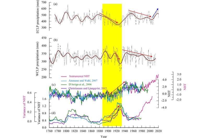
Recently, a research group from the Institute of Earth Environment of the Chinese Academy of Sciences (IEECAS) reconstructed regional hydrological-year precipitation from 1773 to 2020 in the Heichashan Mountains, which was representative to the hydroclimatic variation on the eastern CLP over the past 250 years.
The study was published in Science of the Total Environment on August 12.
The reconstruction revealed that the 20th drying trend had been reversed since the early 2000s, and 2014–2020 was the second wettest period over the past 250 years. 1910–1932 was the longest and driest period over the past centuries.
At the decadal scale, the 1920s was the driest decade, whereas the 2010s was the wettest decade. At the centennial scale, the 19th century was relatively wet, whereas the 20th century was comparatively dry. It was demonstrated that droughts tended to occur in warm periods.
The researchers disclosed that hydroclimate had changed synchronously on the eastern and the western CLP for most of the past two centuries. However, east-west regional differences existed in the 1890s–1920s drying process and in the timing of the onset of the 20th-century aridity.
The study also highlighted that in addition to the influence of the Asian summer monsoon system, a regime shift in northern hemisphere temperature was related to the 1920s megadrought.
More information: Qiufang Cai et al, Insight into spatial-temporal patterns of hydroclimate change on the Chinese Loess Plateau over the past 250 years, using new evidence from tree rings, Science of The Total Environment (2022). DOI: 10.1016/j.scitotenv.2022.157960
Journal information: Science of the Total Environment
Provided by Chinese Academy of Sciences


