New remote sensing methods are well-suited for the detection of tree species

Researchers from the Department of Geographical and Historical Studies at the University of Eastern Finland, and from the Finnish Environment Institute, are collaborating in the IBC-Carbon project to develop novel remote sensing methods that can be used explore forest biodiversity and carbon sequestration.
Led by Professor of Environmental Geoinformatics Timo Kumpula and Leading Scientist Petteri Vihervaara (Finnish Environment Institute), the group has tested various remote sensing methods to detect different tree species in the Evo research area, among other places. In Evo, very high-resolution remote sensing data have been collected from an area of 83 square kilometers, which constitutes a diverse research environment that comprises conserved old forests, commercial forests and a popular camping area.
The researchers have been particularly interested in detecting the European aspen from among other tree species. The European aspen is an ecologically valuable tree species because it is associated with a rich and versatile selection of flora and fauna that maintain forest biodiversity.
"The European aspen is associated with an exceptionally large number of different organisms, such as insects, fungi, lichen, cavity-nesting birds, and endangered species. The European aspen also has a history of being an undesired species from the 1960s to the 1980s, when young aspens were linked to the spread of a fungal disease to pine trees in commercial forests. Later, the significance of the European aspen for forest biodiversity has been understood. High biodiversity values are particularly associated with aspens with a thick bark. Dead aspen trees also maintain biodiversity," says Researcher Sonja Kivinen.
Different remote sensing methods yield versatile data
To detect different tree species, the IBC-Carbon research group has conducted hyperspectral and laser scanning measurements from an aircraft, as well as multi-spectral measurements by using drones.
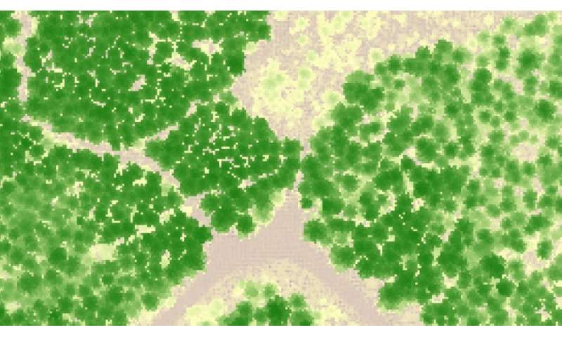
Unlike conventional aerial images, hyperspectral measurement yields data from hundreds of different wavelength ranges, which makes it possible to observe reflection differences between different tree species in the terrain. Laser scanning, on the other hand, enables three-dimensional measurement of objects, providing information on, for example, tree height and crown structure.
The accuracy achieved by the research group in the detection of the European aspen varied between 84% and 92% in the hyperspectral and laser scanning data; in the data collected by drones, the accuracy was 86%.
"This means that the methods used in the study are well-suited for the detection of different tree species. By combining reflection data from different wavelength ranges and laser scanning data on tree height and crown structure, we are able to perform more detailed mapping of trees," Researcher Arto Viinikka says.
However, there are differences in the collection of remote sensing data. From an aircraft, it is possible to cover a larger area at once, whereas a drone allows rapid and multiple flights over smaller areas. The fact that aircraft flights are considerably more expensive than drones also dictates the terms of research.
"The use of data collected from drones is becoming more common rapidly, especially when high-resolution data are needed," says Researcher Anton Kuzmin.
"Modern machine learning methods also enable an increasingly detailed analysis of the data. It is possible to produce information on the occurrence of the European aspen up to the level of individual trees, and this also provides more detailed information on biodiversity," Researcher Janne Mäyrä says.
-
Crown height model formed from a laser scanning point cloud. Credit: University of Eastern Finland -
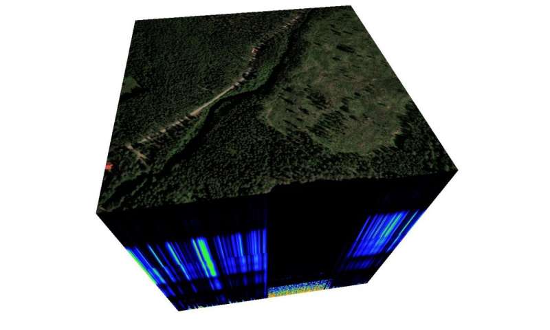
A hyperspectral data cube. Credit: University of Eastern Finland -
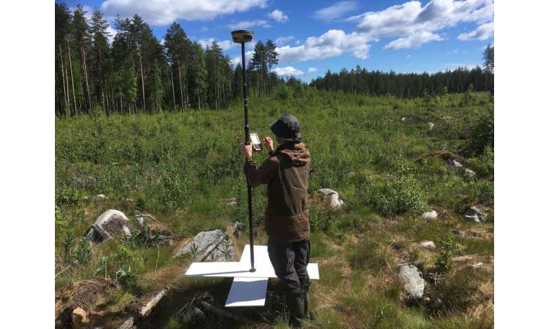
Marking aerial imaging correction points with a GPS device. Credit: University of Eastern Finland -
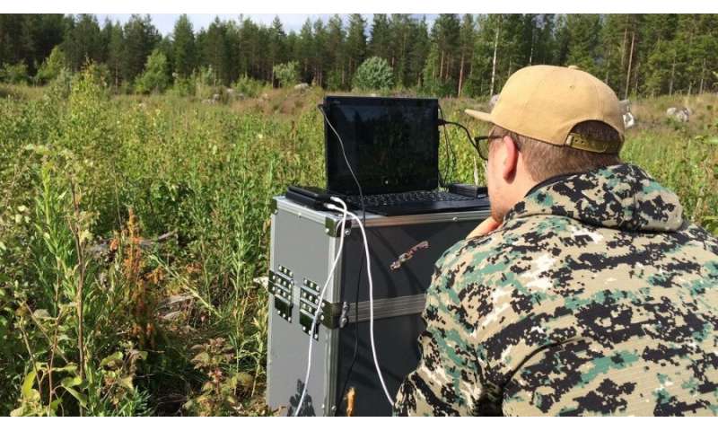
Air traffic control station in a felling site. Researcher Anton Kuzmin is monitoring the progress of a fixed wing drone flight. Credit: University of Eastern Finland
IBC-Carbon research has reached a midway point
Led by the Finnish Environment Institute and funded by the Strategic Research Council at the Academy of Finland, the IBC-Carbon consortium was launched in 2018 and is now in its second three-year funding period.
The consortium's research addresses the challenges the bioeconomy's growth expectations and higher felling rates pose on Finnish forest management, on forest biodiversity, and on the development of carbon sinks that slow down climate change. The coexistence of biodiversity, safeguarding of various ecosystem services, and sustainable use of forests is considered increasingly important.
The objective of IBC-Carbon is to support decision-making by providing information on the different values of forests on the basis of modeling and diverse sets of data. In the coming period, the project will also work closely with the Finnish Ecosystem Observatory (FEO), which is coordinated by the Finnish Environment Institute. The new biodiversity monitoring methods developed by IBC-Carbon, which are based on remote sensing and machine learning, will be immediately available in FEO.
"The IBC-Carbon project funded by the Strategic Research Council has been an exceptionally long research project. Our activities are in full gear and, thanks to the diverse know-how and motivation of our experts, it has been possible to take interesting approaches to research. In addition, the project is linked to and strongly supports the activities of the Forests and Bioeconomy (FOBI) research community at the University of Eastern Finland," Timo Kumpula says.
More information: Sonja Kivinen et al, A keystone species, European aspen (Populus tremula L.), in boreal forests: Ecological role, knowledge needs and mapping using remote sensing, Forest Ecology and Management (2020). DOI: 10.1016/j.foreco.2020.118008
Anton Kuzmin et al, Detection of European Aspen (Populus tremula L.) Based on an Unmanned Aerial Vehicle Approach in Boreal Forests, Remote Sensing (2021). DOI: 10.3390/rs13091723
Janne Mäyrä et al, Tree species classification from airborne hyperspectral and LiDAR data using 3D convolutional neural networks, Remote Sensing of Environment (2021). DOI: 10.1016/j.rse.2021.112322
Arto Viinikka et al, Detecting European Aspen (Populus tremula L.) in Boreal Forests Using Airborne Hyperspectral and Airborne Laser Scanning Data, Remote Sensing (2020). DOI: 10.3390/rs12162610
To learn more about the IBC-Carbon project, please visit www.ibccarbon.fi/en-US.
More information about the work package led by Timo Kumpula is available at www.ibccarbon.fi/fi-FI/Tyopaketit/Tyopakett_4.
Journal information: Forest Ecology and Management
Provided by University of Eastern Finland


