Global mapping projects aid humanitarian organisations

In recent years, free digital world maps like OpenStreetMap (OSM) have become a vital instrument to support humanitarian missions over the entire world. In disaster management as well as the implementation of the United Nations Sustainability Development Goals (SDGs), geodata compiled by the volunteer mapper community open up new possibilities to coordinate aid interventions and carry out sustainability projects. The mapping data are collected either locally using a smartphone and GPS device or on the basis of satellite images. An international team of researchers led by geoinformation scientists based at Heidelberg University is studying the evolution of humanitarian mapping and its repercussions on OpenStreetMap.
Digital services and platforms like the "HOT Tasking Manager" are used to coordinate the activities of volunteer mappers in all parts of the world as well as used by aid organizations to better respond to humanitarian disasters. "In recent years, the HOT Tasking Manager has become a vital tool for humanitarian mapping. Until now, however, there has been no comprehensive study on its effects or how it influences the overall development of OpenStreetMap and the make-up of the incorporated data," explains Benjamin Herfort, a doctoral candidate in the Geoinformatics Department at the Institute of Geography of Heidelberg University and research assistant at the Heidelberg Institute for Geoinformation Technology (HeiGIT), which is supported by the Klaus Tschira Foundation.
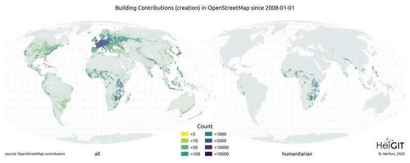
The first long-term study of all humanitarian mapping projects in the "HOT Tasking Manager" indicates that between January 2008 and May 2020 more than 60 million buildings and over four million roads were added to OpenStreetMap, primarily in regions with low and medium human development. This form of humanitarian mapping thus actively contributes to the diversification of mapping activities and the geodata in OpenStreetMap. "However, a strong focus on the Global North still persists," states Benjamin Herfort. "In spite of the progress over recent years, regions which, according to the Human Development Index, are considered to have low and medium human development account for only 28 percent of buildings labeled on OpenStreetMap and only 16 percent of mapped streets—although half of the world's population lives there."
This inequality is largely founded in socio-economic and demographic factors. At the same time, variables like sudden natural disasters play a major role. They can launch a spate of humanitarian mapping activities, as seen for the first time in 2010 after the earthquake in Haiti. On the other hand, local and regional factors can impede humanitarian mapping, especially if there is no Internet access.
According to the study, humanitarian mapping with the "HOT Tasking Manager" has an overall positive impact on the geographical distribution of global mapping activities in OpenStreetMap. Additional studies are already being planned to bring to light the development of all humanitarian mapping activities in OSM including beyond the "HOT Tasking Manager." Based on their current analyses, however, the researchers have already identified opportunities for further development. They recommend that the humanitarian mapper community and participating organizations shift their priority from documenting completed mapping activities to specifically evaluating regions from which more data is needed.
They also encourage taking a long-term view of mapping projects with a humanitarian focus, apart from acute events like natural disasters. Local mapper communities would then form in affected or vulnerable regions that would continually maintain data in the OpenStreetMap, keeping these regions visible on the map. Further, the researchers support simplifying local data collection by strengthening the technical infrastructure and engaging as many different social groups as possible in map-making. Benjamin Herfort: "This approach supports participation and opens up new local perspectives, thereby creating potential for development."
The results of the study were published in the journal Scientific Reports.
More information: Benjamin Herfort et al, The evolution of humanitarian mapping within the OpenStreetMap community, Scientific Reports (2021). DOI: 10.1038/s41598-021-82404-z
Journal information: Scientific Reports
Provided by Heidelberg University


