Is Earth on fire? Data shows almost five times as many wildfires over last year
, processed by ESA on ONDA Copernicus DIAS")
Wildfires have been making headlines again this month, with multiple fires burning in Lebanon and California, but these are just some of the many fires 2019 has seen. Fires in the Amazon sparked a global outcry this summer, but fires have also been blazing in the Arctic, France, Greece, Indonesia as well as many other areas in the world.
Data from the Sentinel-3 World Fire Atlas shows that there were almost five times as many wildfires in August 2019 compared to August 2018, but a detailed analysis reveals precisely where these fires have been occurring—most of which were in Asia.
The Copernicus Sentinel-3 mission recorded 79,000 fires in August this year, compared to just over 16,000 fires detected during the same period last year. These figures were achieved by using data from the Sentinel-3 World Fire Atlas Prototype, which is also able to provide a breakdown of these fires per continent.
The data reveals 49 percent of fires were detected in Asia, around 28 percent were detected in South America, 16 percent in Africa, and the remaining were recorded in North America, Europe and Oceania.
Working like thermometers in the sky, the sensors on satellites measure thermal infrared radiation to take the temperature of Earth's land surfaces. This information is used to detect and monitor the heat emitted by the fires.
Using its two dedicated fire channels, the Sentinel-3 World Fire Atlas uses a simplified operational version derived from Wooster et al. 2012 in order to identify all active fires at night.
-
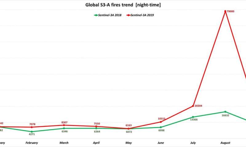
The trend of wildfires detected in 2019 are shown in red, while fires detected in 2018 can be seen in green. The Sentinel-3 World Fire Atlas shows 70 000 fires in August 2019, compared to just over 16 632 fires in August 2018. Credit: European Space Agency -
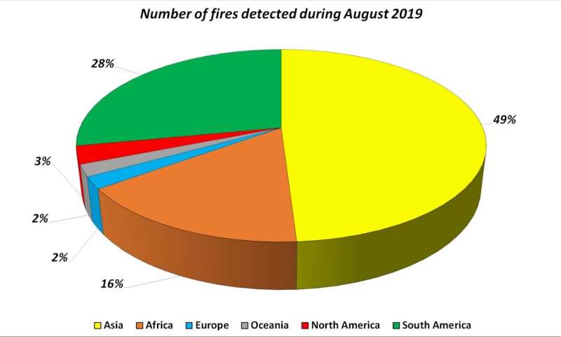
Out of the 79 000 wildfires detected in 2019, this pie chart shows the breakdown of the fires by continent. Around half of the fires were detected in Asia, 28% in South America, 16% in Africa and the remaining in Europe, Oceania and North America. Credit: European Space Agency
Data gathered are used to plot the number of fires occurring monthly. The number of input images from Copernicus Sentinel-3A satellite were around the same from one year to the other.
Even if the atlas cannot pick up all fires due to satellite overpass constraints and cloud coverage, it is statistically representative from one month to the other and from one year to the other.
ESA's Olivier Arino comments, "We have never seen an increase of wildfires of this kind since the ATSR World Fire Atlas was created in 1995."
-
The Copernicus Sentinel-2 mission captured the fires over Borneo on 13 September 2019. Credit: contains modified Copernicus Sentinel data (2019), processed by ESA, CC BY-SA 3.0 IGO -
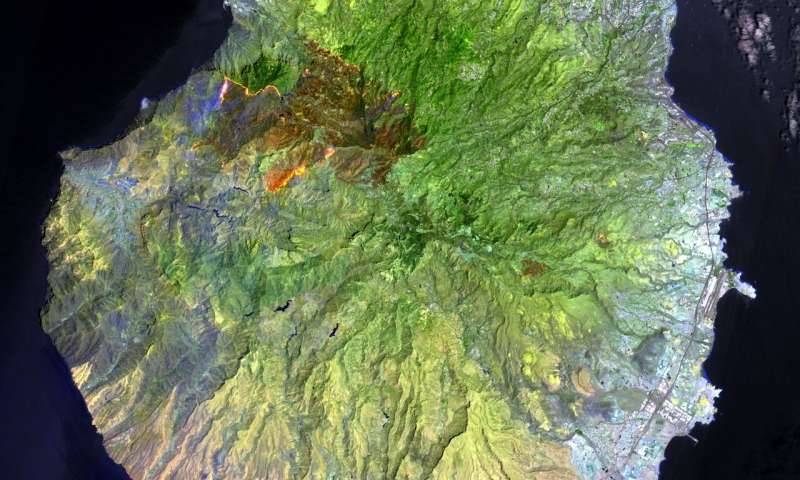
An unprecedented wildfire has ripped through the island of Gran Canaria, one of Spain’s Canary Islands off the northwest coast of Africa. The wildfire, which started on Saturday 17 August, has now started to subside after engulfing around 10 000 hectares of land, leading to the evacuation of over 9000 people. This false colour image, captured on 19 August, was created using the shortwave infrared bands from the Copernicus Sentinel-2’s instrument, and allows us to clearly see the fires on the ground in bright orange. Burn scars are visible in dark brown. These bands also allow us to see through smoke – but not clouds. Credit: contains modified Copernicus Sentinel data (2019), processed by ESA, CC BY-SA 3.0 IGO -
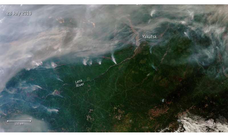
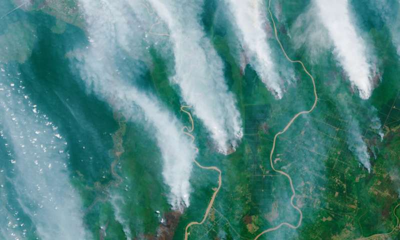
Hundreds of wildfires have broken out in Siberia, some of which can be seen in this image captured from space on 28 July 2019. Almost three million hectares of land are estimated to have been affected, according to Russia’s Federal Forestry Agency. This Copernicus Sentinel-3 image shows a number of fires, producing plumes of smoke. The smoke has carried air pollution into the Kemerovo, Tomsk, Novosibirsk, and Altai regions. Credit: contains modified Copernicus Sentinel data (2019), processed by ESA, CC BY-SA 3.0 IGO
Quantifying and monitoring fires is important for the ongoing study of climate because they have a significant impact on global atmospheric emissions, with biomass burning contributing to the global budgets of greenhouse gases, like carbon dioxide.
One of the biggest problems during and after fires is obtaining an overall view of the fires evolution and potential damage. With fires seen from space, Earth observation is also being used to detect and monitor the active spots over affected areas.
The prototype product and algorithm were presented at the remote sensing of forest fire EARSeL conference in Rome on 3 October 2019.
More information: World Fire Atlas: www.sciencedirect.com/science/ … ii/S0034425711002252
Provided by European Space Agency


