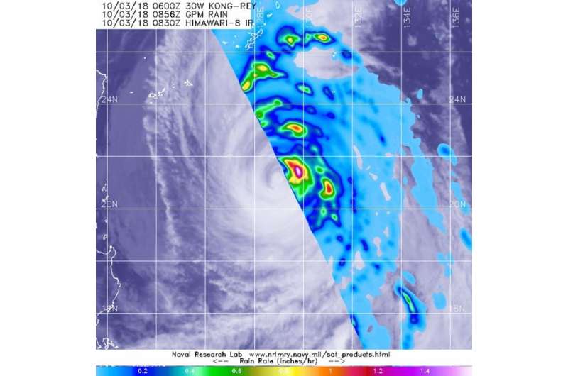
NASA gets a look at the rainfall rates within Typhoon Kong-Rey

The Global Precipitation Measurement mission or GPM core satellite passed over Typhoon Kong-Rey moving through the Northwestern Pacific Ocean and found heaviest rainfall occurring in the storm's eyewall.
The eyewall of a tropical cyclone refers to the powerful thunderstorms that form a ring around the open eye. In the eye, air descends and prevents cloud formation. Around the eye, strong uplift of air creates powerful thunderstorms that extend high into the troposphere.
The GPM core observatory satellite passed over Typhoon Kong-Rey on Oct. 3 at 4:36 a.m. EDT (0836 UTC) and measured rainfall rates occurring within the storm. Data collected by the GPM satellite's Microwave Imager (GMI) showed that powerful storms in the northeastern eyewall were producing the heaviest rainfall. Those storms were producing rainfall at a rate greater than 1.4 inches per hour. GPM is a joint mission between NASA and the Japan Aerospace Exploration Agency, JAXA.
The Joint Typhoon Warning Center or JTWC noted "animated enhanced infrared satellite imagery shows that convection has continued to rapidly weaken. The eye feature is now only 5 nautical miles wide and continues to erode."
At 11 a.m. EDT (1500 UTC) the center of Kong-Rey was located near 22.0 degrees north latitude and 128.4 degrees east longitude. That's about 298 nautical miles south of Kadena Air Base, Okinawa Island, Japan. Kong-Rey was moving toward the north-northwest. Maximum sustained winds remain near 115 mph (185 kph/100 knots).
JTWC forecasts Kong-Rey to continue moving north-northwest over the next couple of days, and its center will remain west of Okinawa and Amami Oshima. Kong-Rey is forecast to turn northeast and move into the Sea of Japan on Oct. 6.
Provided by NASA's Goddard Space Flight Center


