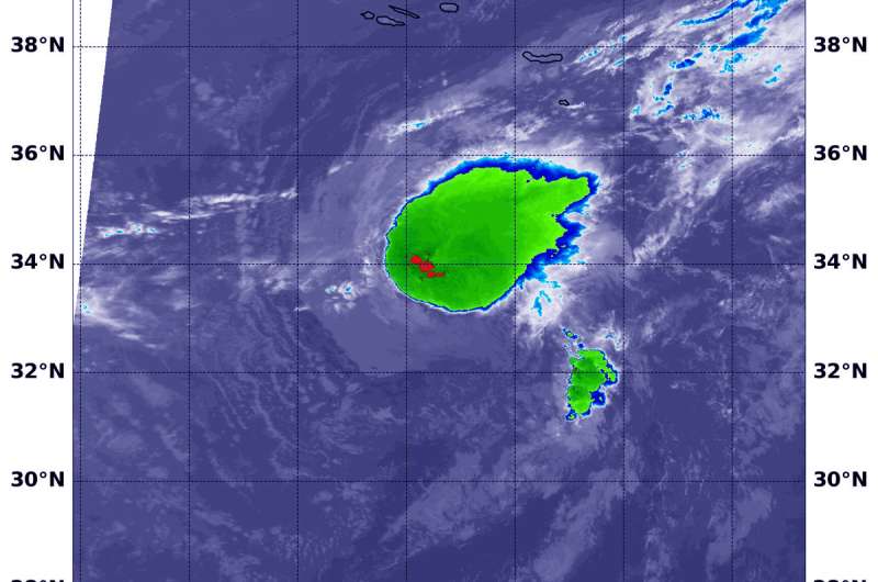
NASA infrared imagery reveals wind shearing Tropical Depression Joyce

NASA's Aqua satellite provided an infrared look at Tropical Depression Joyce and found wind shear was pushing the bulk of clouds and showers to the east of the center.
The National Hurricane Center noted at 5 a.m. EDT on Sept. 18, "The latest convective burst associated with Joyce is weakening due to the effects of 35 to 40 knots of westerly vertical [wind] shear and very dry mid-level air."
In general, wind shear is a measure of how the speed and direction of winds change with altitude. Wind shear can tear a tropical cyclone apart or weaken it.
At 11:20 p.m. EDT on Sept. 17 (0320 UTC on Sept. 18), Moderate Resolution Imagine Spectroradiometer or MODIS instrument aboard NASA's Aqua satellite analyzed Tropical Depression Joyce in infrared light. MODIS found a small area of coldest cloud top temperatures around the center of circulation. Those were as cold as or colder than minus 70 degrees Fahrenheit (minus 56.6 degrees Celsius). The bulk of the storm, however, was being pushed to the northeast from the wind shear.
NASA research has found that cloud top temperatures as cold as or colder than the 70F/56.6C threshold have the capability to generate heavy rainfall.
At 5 a.m. EDT (0900 UTC), the center of Tropical Depression Joyce was located near latitude 32.9 degrees north and longitude 27.6 degrees west. That's 355 miles (570 km) south of the Azores Islands.
The depression is moving toward the south-southeast near 6 mph (9 kph). A turn toward the south is forecast later today, followed by a motion toward the southwest on Wednesday, Sept. 19 and Thursday, Sept. 20. Maximum sustained winds are near 35 mph (55 km/h) with higher gusts. Gradual weakening is expected during the next couple of days, and Joyce is forecast to become a remnant low later today or tonight.
Provided by NASA's Goddard Space Flight Center


