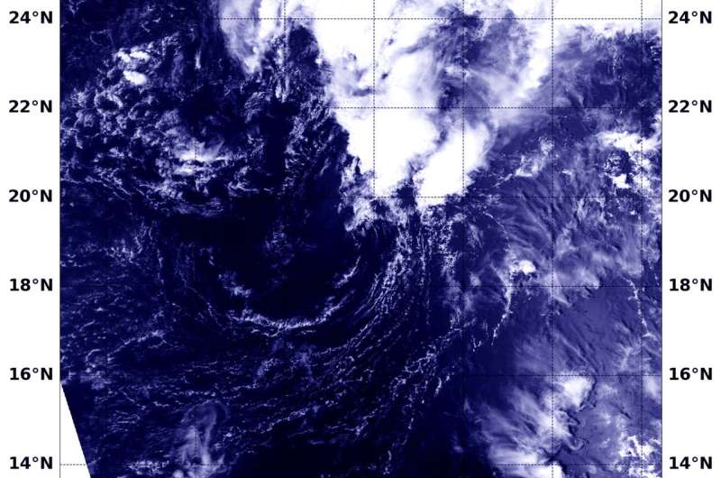
NASA sees post-Tropical Cyclone Lane come to an end

The once hurricane that dropped record-setting rainfall on the Hawaiian Islands has come to an end in the Central Pacific Ocean and NASA-NOAA's Suomi NPP satellite captured a visible image of its final hours.
The once hurricane that dropped record-setting rainfall on the Hawaiian Islands has come to an end in the Central Pacific Ocean and NASA-NOAA's Suomi NPP satellite captured a visible image of its final hours.
NASA-NOAA's Suomi NPP satellite flew over Post-Tropical Cyclone Lane on Aug. 28 at 7:54 p.m. EDT (2354 UTC).The Visible Infrared Imaging Radiometer Suite (VIIRS) instrument aboard NASA-NOAA's Suomi NPP satellite provided a visible image that showed wind shear has taken its toll on the storm and pushed all of the clouds northeast of the cloud-less center of circulation.
The final warning came from NOAA's Central Pacific Hurricane Center at 0300 UTC on Aug. 29 (11 p.m. EDT on Aug. 28) when Lane's center was located near 19.5 degrees north latitude and 168.3 degrees west longitude. That's 330 miles south-southwest of French Frigate Shoals, Hawaii. At the time, maximum sustained winds were near 28.7 mph (25 knots/46.3 kph).
Lane has ceased to be a tropical cyclone and will dissipate soon.
Provided by NASA's Goddard Space Flight Center


