GPM probes Category 4 Tropical Cyclone Cebile

NASA analyzed a major tropical cyclone spinning in the Southwestern Indian Ocean and measured its rainfall.
On January 27, Tropical Cyclone Cebile formed in the southwest Indian Ocean southeast of Diego Garcia. On January 31, Tropical Cyclone Cebile became the most powerful tropical cyclone to form in the southern hemisphere this year. Maximum sustained wind speeds were estimated at 120 knots (138 mph) early in the day making Cebile the equivalent of a category 4 hurricane on the Saffir-Simpson hurricane wind scale.
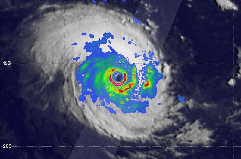
The GPM core observatory satellite passed directly above the well-defined circular eye of Tropical Cyclone Cebile on January 31, 2018 at 0034 UTC. Rainfall intensity and coverage within Cebile were revealed by GPM's Microwave Imager (GMI) and Dual Frequency Precipitation Radar (DPR) instruments. GPM's GMI and DPR showed that intense thunderstorms on the southern side of Cebile's nearly clear eye were dropping rain at a rate of more than 228 mm (9 inches) per hour.
GPM's Dual Frequency Precipitation Radar (DPR) were used to show 3-D cut-a-way views of the precipitation structure within tropical cyclone Cebile. Heavy downpours within the tropical cyclone were frequently returning radar reflectivity values greater than 54 dBZ to the satellite. GPM's radar also showed that tall thunderstorms in Cebile's eye wall were reaching heights above 14.4 km (8.9 miles).
By 10 a.m. EST (1500 UTC) on Jan. 31, Cebile's maximum sustained winds were near 132 mph (115 knots/213 kph). It was centered near 15.6 degrees south longitude and 77.1 degrees east latitude, approximately 583 nautical miles south-southeast of Diego Garcia. Cebile has tracked northwestward at 4. 6 mph (4 knots/7.4 kph).
At that time, animated multispectral satellite imagery showed a symmetric system with a clear eye feature, a very sharp eyewall and deep convective banding. The eye feature had gradually contracted from 30 to 25 nautical miles over the six hours previous.
Today tropical cyclone Cebile is moving through an environment that is very favorable for maintaining the tropical cyclone's power. Low vertical wind shear and very warm ocean temperatures are having a positive effect on Cebile. The Joint Typhoon Warning Center (JTWC) predicts that this will change tomorrow. Vertical wind shear is expected to increase and cooler waters are predicted to sap the power of the tropical cyclone.
Provided by NASA's Goddard Space Flight Center


