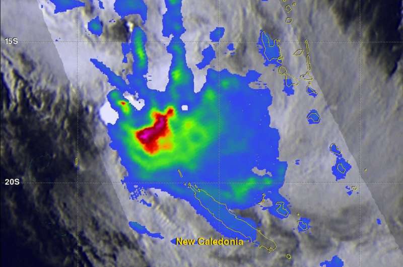
GPM satellite analyzes Tropical Cyclone Fehi's rainfall

The Global Precipitation Measurement mission or GPM core satellite passed over Tropical Cyclone Fehi in the Southern Pacific Ocean season and identified heavy rainfall in the system.
Fehi formed northwest of New Caledonia on January 28, 2018 at 0000Z (Jan. 27 at 7 p.m. EST). The GPM core observatory satellite passed over Tropical Cyclone Fehi on January 28, 2018 at 3:42 a.m. EST (0842 UTC). The tropical cyclone had winds of about 35 knots (40 mph) when the GPM satellite passed above. Fehi intensified to have peak sustained wind speeds of about 50 knots (58 mph) and still had winds of tropical storm intensity as it moved by to the west of New Caledonia.
Data collected by the GPM satellite's Microwave Imager (GMI) showed that powerful storms northwest of New Caledonia were dropping rain at a rate of greater than 77 mm (3 inches) per hour. GMI also showed that Fehi was producing rain over a large area of the ocean extending from west of New Caledonia to the Loyalty Islands. GPM is a joint mission between NASA and the Japanese space agency JAXA.
The Joint Typhoon Warning Center (JTWC) issued their final warning on Fehi on January 30 at 10 a.m. EST. At that time, Fehi had already moved south of New Caledonia. Maximum sustained winds had dropped to 40 mph (35 knots/62 kph) and the storm continued to weaken. Fehi was centered near 29.1 degrees south latitude and 163.8 degrees east longitude. That's about 238 nautical miles west-northwest of Kingston Island. Fehi was moving to the south at has tracked southward at 19.5 mph (17 knots/31.5 kph).
The JTWC noted "Animated enhanced infrared satellite imagery depicts a fully exposed low level circulation center and a large comma-shaped area of convective activity poleward and eastward of the low-level center." Fehi is in an environment with strong vertical wind shear and sea surface temperatures below the 26.6 degree Celsius (80 degree Fahrenheit) threshold needed to maintain a tropical cyclone's strength. On Jan. 30, the storm was transitioning into an extra-tropical cold core system.
Provided by NASA's Goddard Space Flight Center


