NASA sees a re-strengthened Tropical Storm Kai-Tak

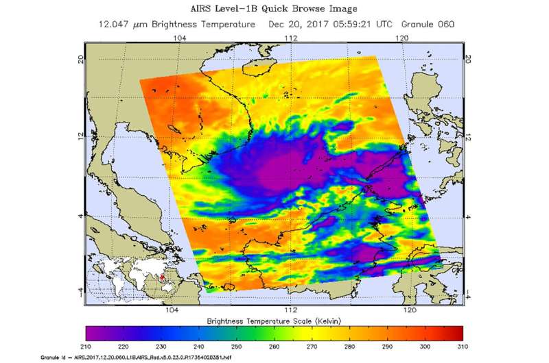
NASA's Aqua satellite passed over the South China Sea and infrared imagery showed that Kai-Tak re-strengthened into a tropical storm. Infrared data from Aqua's AIRS instrument revealed very cold cloud top temperatures in powerful thunderstorms.
The Atmospheric Infrared Sounder aboard NASA's Aqua satellite captured an infrared image of the newly strengthened Tropical Storm Kai-Tak on Dec. 20 at 12:59 a.m. EST (0559 UTC). Infrared data from the Atmospheric Infrared Sounder or AIRS instrument that flies aboard Aqua provides cloud top temperatures.
AIRS data showed the coldest cloud tops and strongest storms west of the center of circulation and over the South China Sea. There was also another area of strong storms, east of the center and over the island of Palawan. Cloud top temperatures in both of those areas were colder than minus 63 degrees Fahrenheit (minus 53 degrees Celsius). NASA research has shown that storms with cloud tops that cold have the potential to generate heavy rainfall.
On Dec. 20 at 10 a.m. EST (1500 UTC) the Joint Typhoon Warning Center reported that
Tropical Storm Kai-Tak had maximum sustained winds near 35 knots (40 mph/62 kph). The storm was moving southwest at 7 knots (8 mph/~13 kph). Kai-Tak was centered near 6.7 degrees north latitude and 111.5 degrees east longitude, about 387 nautical miles southeast of Ho Chi Minh City, Vietnam.
The Joint Typhoon Warning Center or JTWC expects Kai-Tak to move in a southwesterly direction over the next two days. JTWC expects Kai-Tak to approach the Malay Peninsula by Dec. 22.
Provided by NASA's Goddard Space Flight Center


