NASA sees tiny Tropical Depression Irwin winding down

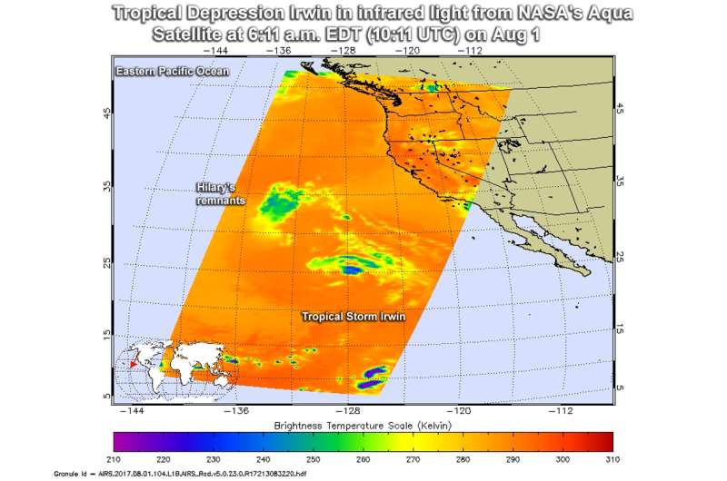
Infrared imagery from NASA looked at cloud top temperatures in Tropical Depression Irwin found a very small area of cold clouds and no strong storms. Irwin appeared as a swirl of clouds as it continued to wind down.
The Atmospheric Infrared Sounder or AIRS instrument aboard NASA's Aqua satellite looked at cloud top temperatures in Tropical Depression Irwin using infrared light. The AIRS data were taken on 6:11 a.m. EDT (10:11 UTC) on Aug 1 and showed cloud top temperatures had warmed since the day before. Irwin basically consists of a tight swirl of low clouds devoid of deep convection.
The AIRS image also revealed a smaller area of cold cloud tops northwest of Irwin. That area are the remnant clouds of former tropical storm Hilary.
Basically, the higher the cloud tops, the colder and stronger the storms than make up the tropical cyclone. So, infrared light as that gathered by the AIRS instrument can identify the strongest sides of a tropical cyclone. Of course, infrared data can also tell if temperatures have warmed, meaning that the uplift has weakened in the system. Weaker uplift means less creation of the thunderstorms that make up a tropical cyclone.
That's exactly what happened to Irwin as it moved over cool waters.
The infrared data was false-colored at NASA's Jet Propulsion Laboratory in Pasadena, California, where AIRS data is managed.
National Hurricane Center (NHC) noted at 11 a.m. EDT (1500 UTC) the center of Tropical Depression Irwin was located near 25.9 degrees north latitude and 129.2 degrees west longitude. That's about 1,230 miles (1,980 km) west-northwest of the southernmost tip of Baja California, Mexico. Irwin was moving toward the north-northwest near 10 mph (17 kph). A motion toward the northwest should begin later today. Maximum sustained winds have decreased to near 35 mph (55 kph) with higher gusts.
The NHC said Irwin is forecast to become a remnant low later today, August 1.
Provided by NASA's Goddard Space Flight Center


