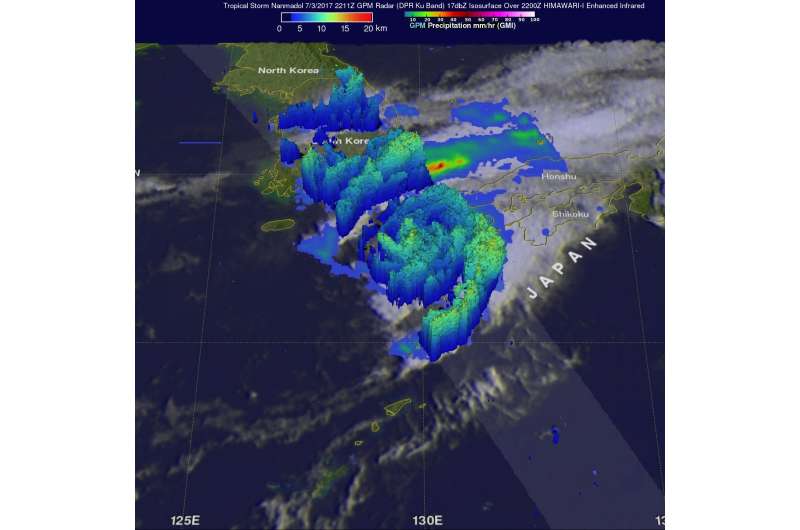
NASA measures Tropical Cyclone Nanmadol's Japan rainfall rates

Although the remnants of Tropical Storm Nanmadol have pushed into the north central Pacific Ocean, the rainfall it left behind caused flooding in Japan. NASA and the Japan Aerospace Exploration Agency's Global Precipitation Measurement mission or GPM core satellite calculated the rate in which rain was falling over the area.
Tropical storm Nanmadol caused heavy flooding and one death when it hit southwestern Japan a few days ago. The GPM core observatory satellite had an excellent view of Nanmadol as the tropical cyclone approached the island of Kyushu on July 3, 2017 at 2211 UTC 6:11 p.m. EDT). GPM's Microwave Imager (GMI) and Dual-frequency Precipitation Radar (DPR) collected data that revealed the amount and intensity of precipitation falling from Nanmadol. GPM's DPR found rain falling at a rate of over 84.4 millimeters (3.3 inches) per hour in an intense band of rain in the Korea Strait. Another band of heavy rain was seen approaching western Kyushu in the analysis made at NASA's Goddard Space Flight Center in Greenbelt, Maryland.
The GPM satellite's Radar (DPR Ku band) data were utilized to create a 3-D structure of storm tops in a cross-section of then Tropical Storm Nanmadol. The 3-D slice through the tropical cyclone revealed a feeder band of thunderstorms moving into southern Kyushu contained powerful storms that were reaching heights above 13 kilometers (8 miles).
Tropical storm Nanmadol moved eastward into the northern Pacific Ocean after dropping heavy showers over the Japanese islands of Kyushu, Shikoku and southern Honshu. Nanmadol was downgraded to tropical depression and the final warning was issued by the Joint Typhoon Warning Center (JTWC) on July 4, 2017 at 2100 UTC (5 p.m. EDT).
Provided by NASA's Goddard Space Flight Center


