Oceanographic analysis offers potential crash site of MH370

A group of oceanographers offers a new analysis of the potential crash site of flight Malaysian Airlines flight 370 in the southern Indian Ocean. The researchers, which included scientists from the University of Miami (UM) Rosenstiel School of Marine and Atmospheric Science, used data from buoys that monitor ocean conditions.
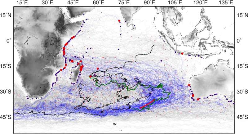
In their analysis the team considered the trajectories of drifting buoys, called drifters, from NOAA's Global Drifter Database and of an ocean numerical model. The researchers included only those data from drifters that were unanchored, or undrogued, to better simulate the buoyancy conditions of airplane debris. The team then produced a simulation model of drifter motion using known oceanographic conditions near the potential crash site.
The analysis showed that it would take six months to one year for the drifters to reach western Australia and one-and-a half to two years to reach eastern Africa. Interestingly, two drifters traveled from the search region to the area of Reunion Island during the period between the crash of flight MH370 and when the airplane flaperon was found.
These results are consistent with the time and location of the aircraft debris that was found off Reunion Island, almost 17 months after the plane disappeared, and with the recently confirmed finding in Mozambique almost two years later.
The trajectories of the undrogued drifters and synthetic drifters revealed several areas of high probability in the southern Indian Ocean where debris from the missing flight could have passed, including vast areas of the South Indian Ocean, some of them in the relative neighborhood of the search area.
This study "highlights the importance of sustained observations to monitor ocean conditions that may serve a suite of applications and studies," said the authors.
The methods developed by the researchers for use in the study could also help scientists track oil spills, and other types of marine debris and pollutants in the ocean.
More information: Joaquin A. Trinanes et al, Analysis of flight MH370 potential debris trajectories using ocean observations and numerical model results, Journal of Operational Oceanography (2016). DOI: 10.1080/1755876X.2016.1248149
Provided by University of Miami


