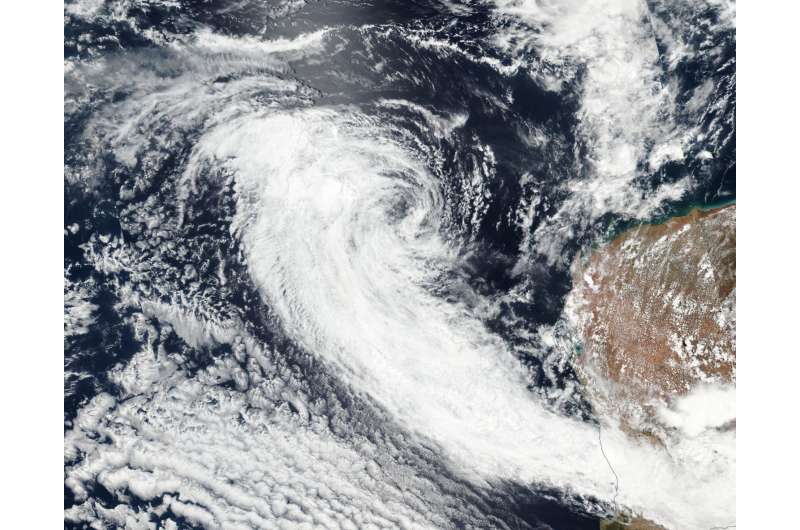
NASA sees Ex-Tropical Cyclone 03S resemble a frontal system

Satellite data from NASA-NOAA's Suomi NPP satellite showed that former Tropical Cyclone 03S resembled a frontal system in the Southern Indian Ocean as it continued moving in a northwesterly direction over cooler sea surface temperatures.
The Joint Typhoon Warning Center or JTWC issued their final warning on the system at 4 a.m. EST (0900 UTC) on January 29, when 03S' maximum sustained winds dropped to 30 knots. At that time, it was about 310 nautical miles northwest of Learmonth, Western Australia. Infrared imagery from the MODIS instrument aboard NASA's Aqua satellite on Jan 29 at 0720 UTC (2:20 a.m. EST) showed that the system appeared elongated.
On Jan. 30, the Visible Infrared Imaging Radiometer Suite (VIIRS) instrument aboard NASA-NOAA's Suomi NPP satellite provided a visible-light image of Ex-Tropical Cyclone 03S that showed its circulation center was being battered by vertical wind shear. That wind shear pushed most of the clouds and thunderstorms west and southwest of the center. The image showed that those clouds were streaming to the southeast, being drawn between a low pressure center over the western part of Western Australia and a high pressure system located to the south-southwest of 03S's remnant center. As a result, the clouds resemble a frontal system over the southern section of Western Australia. Some of the storms associated with that system have triggered warnings on January 30.
The Australian Bureau of Meteorology issued a warning to "Sheep Graziers for the Lower West (where the city of Perth is located) and Great Southern forecast districts" on 5:03 p.m. WST local time on Monday 30 January 2017. The warning stated "Sheep graziers are warned that cold temperatures for this time of year, heavy rain at times and easterly winds are expected during the remainder of Monday and Tuesday. Areas likely to be affected include parts of the Lower West and northern parts of the Great Southern forecast districts. There is a risk of losses of lambs and sheep exposed to these conditions."
JTWC said that the remnant low pressure area will continue to weaken due to unfavorable environmental conditions.
Provided by NASA's Goddard Space Flight Center


