NASA's Terra satellite sees small burst in Tropical Depression Madeline

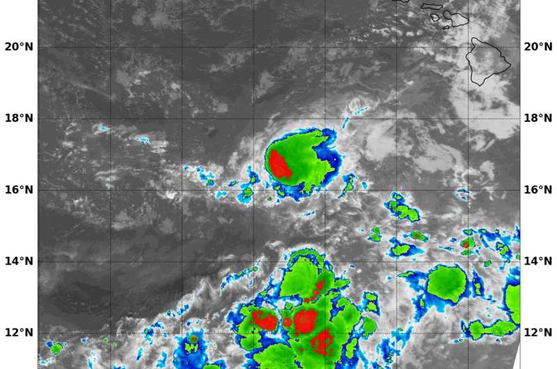
Although Tropical Storm Madeline weakened to a depression, infrared satellite imagery showed a small burst of strength in the storm as strong thunderstorms developed near the center of the storm.
On Sept. 2 at 8:45 a.m. EDT (1245 UTC) NASA's Aqua satellite passed over Tropical Depression Madeline when it was about 400 miles away from the big island of Hawaii. An infrared image from Aqua's Moderate Resolution Imaging Spectroradiometer known as MODIS, showed a small area of cloud tops in Tropical Depression Madeleine were as cold as minus 70 degrees Fahrenheit (minus 56.6 degrees Celsius). Cloud top temperatures that cold indicate storms stretching high into the troposphere and have been shown to generate heavy rain.
Forecasters Jelsema and Ballard said that satellite imagery like the infrared data from Aqua showed that convection (rising air that forms the thunderstorms that make up a tropical cyclone) and development of thunderstorms has increased near Madeline's low level circulation center since the previous advisory, but vertical wind shear and dry mid-level air continues to hamper any attempt of re-organization.
At 11 a.m. EDT (5 a.m. HST/500 UTC), the center of Tropical Depression Madeline was located near 16.2 degrees north latitude and 162.1 degrees west longitude. That's about 445 miles (720 km) southwest of Honolulu, Hawaii and about 490 miles (790 km) east of Johnston Island. The estimated minimum central pressure is 1009 millibars.
Maximum sustained winds are near 35 mph (55 kph) with higher gusts. The depression is moving toward the west near 16 mph (26 kph) and this general motion is expected to continue for the next couple days. Interests on Johnston Island should monitor the progress of Madeline.
Madeline is encountering light to moderate west-southwesterly vertical wind shear combination with very dry air in the mid-levels of the atmosphere which will continue to weaken the storm, despite it being over warm ocean waters. Slow weakening is expected over the next couple of days and Madeline is forecast to become a post-tropical remnant low tonight.
For updated forecasts on Madeline, visit: http://www.prh.noaa.gov/cphc/
Provided by NASA's Goddard Space Flight Center


