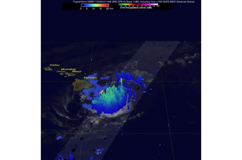
NASA calculated Tropical Storm Darby's rainfall rates over Hawaii

Tropical Storm Darby brought rainfall, gusty winds and rough surf to the Hawaiian Islands over the weekend of July 23 and 24, and was still raining over them on Monday, July 25, 2016. The Global Precipitation Measurement mission or GPM core satellite passed over the islands and calculated rainfall rates from Darby.
Tropical Storm Darby has caused some heavy rainfall in the Hawaiian Islands since hitting the Big Island (Hawaii) on Saturday July 23, 2016. After hitting the big island, Darby passed to the south of Molokai and Maui. Rain falling at a rate of 25.4 mm (1 inch) to 50.8 mm (2 inches) per hour was reported on the island of Oahu as Darby passed to the southwest of the island. The National Weather Service office in Honolulu reported that parts of Interstate H-1 that serves the southern side of Oahu was closed due to flooding on Sunday night. July 24.
The GPM core observatory satellite had an excellent view of tropical storm Darby as it was approaching Hawaii on July 23, 2016 at 1146 UTC (7:46 a.m. EDT). Rainfall was examined in tropical storm Darby by GPM's Microwave Imager (GMI) and Dual-Frequency Precipitation Radar (DPR) instruments. Those instruments found that a line of intense storms southeast of the big island of Hawaii was dropping rain at a rate of over 136 mm (5.4 inches) per hour.
GPM's Radar (DPR Ku Band) measured the 3-D vertical structure of rainfall within tropical storm Darby. DPR found storm top heights of over 13 km (8.1 miles) in areas of the tropical storm. GPM's discovery of 48 dBZ radar reflectivity values in some downpours provided further evidence of intense precipitation within the Darby.
That heavy rain is expected to continue on Monday, July 25, 2016. Bands of thunderstorms east and southeast of the poorly-defined center are expected to drop an additional 1 to 3 inches of rainfall to areas of the Hawaiian Islands today, with locally higher amounts possible.
Forecastern Birchard from NOAA's Central Pacific Hurricane Center (CPHC) noted "Areas of heavy rain and strong thunderstorms continue to develop to the north through east of Darby's poorly-defined center as it interacts with a sharp trough (elongated area of low pressure) aloft, and the system is in the process of losing tropical characteristics. The center passed very close to the island of Kauai overnight, but appeared to remain offshore before taking a turn toward the west-northwest."
At 11 a.m. EDT (5 a.m. HST/1500 UTC) on July 25 the center of Tropical Depression Darby was located near latitude 22.4 north and longitude 160.6 west. That's only 55 miles (90 km) west-northwest of Barking Sands, Hawaii and 190 miles (305 km) west-northwest of Honolulu, Hawaii. Darby had weakened to a tropical depression. Maximum sustained winds were near 35 mph (55 kph) with higher gusts. The estimated minimum central pressure is 1011 millibars.
The depression was moving toward the west near 12 mph (19 kph) and this general motion is expected to continue until dissipation occurs, except for a gradual turn toward the northwest. There are no coastal watches or warnings in effect.
NOAA's CPHC forecasts weakening during the next 48 hours, and Darby is expected to become a post-tropical low by Tuesday before dissipating by Wednesday.
Provided by NASA's Goddard Space Flight Center


