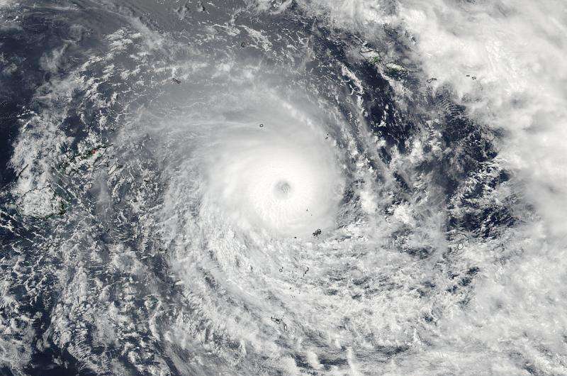
NASA sees major Tropical Cyclone Winston approaching Fiji

Powerful Tropical Cyclone Winston continued to intensify as it neared Fiji and NASA-NOAA's Suomi NPP satellite captured an image of the strengthening storm with a clear eye. Warnings are posted in Fiji as the storm is expected to make landfall there as a major hurricane.
Warnings were in effect in Fiji on Feb. 19 as Winston moved westward in the Southern Pacific Ocean and continued to intensify. In Fiji, a Hurricane Warning remains in effect for Vanuabalavu, Yacata, Mago, Cicia, Tuvuca, Nayau, Koro, Gau, Vanuavatu, Taveuni, Qamea, Laucala, Ovalau, Wakaya and southern Vanua Levu. A Storm Warning remained in effect for Lakeba, Oneata, Moce, Komo, Namuka, Ogea, Moala and rest of Vanua Levu, eastern half of Viti Levu. A Gale Warning was effect for the rest of Fiji. Meanwhile, all warnings in Tonga have been dropped as the storm moved away. For updated forecasts, visit the Fiji Meteorological Service at: http://www.met.gov.fj/.
On Feb. 19 at 01:15 UTC (Feb. 18 at 8:15 p.m. EST) the Visible Infrared Imaging Radiometer Suite (VIIRS) instrument aboard NASA-NOAA's Suomi NPP satellite captured a visible image of Tropical Cyclone Winston in the South Pacific Ocean. The VIIRS image showed that Winston had a 15 nautical mile wide eye circled by a thick band of thunderstorms.
At 1500 UTC (10 a.m. EST) on Feb. 19 Tropical cyclone Winston's increased to 125 knots (143.8 mph/231.5 kph). It was centered near 17.3 degrees south latitude and 177.5 degrees west longitude, about 239 nautical miles (275 miles/442.6 km) east of Suva, Fiji. Winston was moving to the west at 15 knots (17.2 mph/27.7 kph). Winston was generating very rough seas with maximum significant wave height to 38 feet (11.5 meters).
Winston is moving west and the Joint Typhoon Warning Center forecast calls for Winston to strengthen to 130 knots (149.6 mph/240.8 kph) before making landfall on the east coast of Fiji as a major Category 4 hurricane on the Saffir-Simpson Wind Scale.
The Saffir-Simpson Hurricane Wind Scale is a 1 to 5 rating based on a hurricane's sustained wind speed. This scale estimates potential property damage. Hurricanes reaching Category 3 and higher are considered major hurricanes because of their potential for significant loss of life and damage.
According to the Saffir-Simpson Wind Scale for Category 4 hurricane, "catastrophic damage will occur. Well-built framed homes can sustain severe damage with loss of most of the roof structure and/or some exterior walls. Most trees will be snapped or uprooted and power poles downed. Fallen trees and power poles will isolate residential areas. Power outages will last weeks to possibly months. Most of the area will be uninhabitable for weeks or months."
The storm will then veer sharply south and weaken quickly as it moves over an area with increasing vertical wind shear and cooler sea surface temperatures.
Provided by NASA's Goddard Space Flight Center


