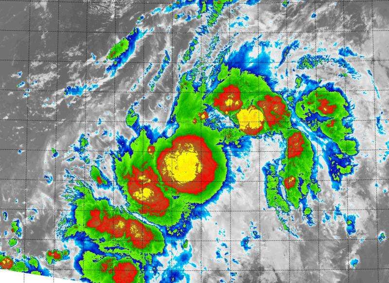
Suomi NPP satellite sees Tropical Depression 14E disorganized

Tropical Depression 14E was born in the Eastern Pacific Ocean early on September 1 when NASA-NOAA's Suomi NPP satellite passed overhead and looked at it in infrared light.
Infrared light shows temperature, which is helpful in determining cloud top temperatures of the thunderstorms that make up a tropical cyclone line Tropical Depression 14E (TD 14E). The colder the storm, the higher they stretch into the troposphere (lowest layer of the atmosphere) and the stronger the storms tend to be.
On September 1 at 0900 UTC (5 a.m. EDT), NASA-NOAA's Suomi NPP satellite passed over TD 14E and the Visible Infrared Imaging Radiometer Suite (VIIRS) instrument aboard looked at the developing depression in infrared light. The VIIRS imagery showed fragmented thunderstorms around the center of circulation that appears to be stretched from southwest to northeast. The National Hurricane Center noted that the cloud pattern continues to be elongated and the convection (rising air that forms thunderstorms) is not very well organized at this time.
On September 1 at 11 a.m. EDT (1500 UTC), the center of TD 14E was located near latitude 13.0 North and longitude 113.6 West. That's about 725 miles (1,165 km) south-southwest of the southern tip of Baja California, Mexico. Maximum sustained winds remain near 35 mph (55 kph) and the National Hurricane Center said the depression is forecast to become a tropical storm later on September 1 or 2.
TD 14E's estimated minimum central pressure is 1006 millibars. The depression is moving toward the north-northwest near 8 mph (13 kph), and this general motion with a gradual turn to the north is anticipated during the next 2 days.
NHC Forecaster Avila said that TD 14E has a chance to strengthen a little bit during the next day or two, before stronger southerly upper-level winds ahead of a trough (elongated area of low pressure) begin to impact the cyclone.
Provided by NASA's Goddard Space Flight Center


