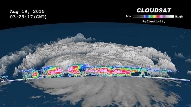
CloudSat slices into Super Typhoon Atsani

NASA's CloudSat Satellite passed over Super Typhoon Atsani as it moved through the western North Pacific Ocean. CloudSat looked at the super typhoon from the side, revealing heavy rainfall in a sloping eyewall.
Typhoon Atsani strengthened into a super typhoon on August 19, 2015 at 0000 UTC. CloudSat flew over Atsani at 03:27 UTC, shortly after it became a super typhoon when maximum sustained winds were near 130 knots (150 mph). Atsani was equivalent to a category 4 strength hurricane.
CloudSat's cloud profiling radar (CPR), passed just to the west of Super Typhoon Atsani's large eye, and saw a portion of the eyewall (the powerful thunderstorms surrounding the open eye). CloudSat radar showed the sloping nature of the eyewall and the very heavy rainfall associated with this area (where the CloudSat radar signal dips and becomes very narrow).
The CloudSat data also highlights the outward sloping areas outside the eyewall area and the deep convective (rising air that forms thunderstorms that make up the typhoon) cloud tops in the areas northwest and southeast of the eye.
"Areas underneath the cirrus canopy reveal areas of limited and/or light precipitation with most of the convection on the southern side of the storm," said Natalie Tourville, atmospheric scientist at the Cooperative Institute for Research in the Atmosphere, Colorado State University. "Cloud top heights average 16 kilometers (9.92 miles).The cirrus canopy extends much farther outward over the southern section of the storm."

On August 20 at 0900 UTC (5 a.m. EDT), Super Typhoon Atsani had maximum sustained winds near 135 knots (155.4 mph/250 kph). Typhoon-force winds extended out 60 nautical miles (69 miles/111 km) from the center, while tropical-storm-force winds extended to 225 nautical miles (259 miles/416.7 km) from the center, making Atsani a very large and powerful storm.
Atsani was centered near 22.0 North latitude and 148.6 East longitude, about 436 nautical miles (501.7 miles/807.5 km) east-southeast of Iwo To island, Japan. It was moving to the northwest at 12 knots (13.8 mph/22.2 kph).
Forecasters at the Joint Typhoon Warning Center expect Atsani to weaken after today, August 20. Atsani is expected to become an extra-tropical system as it curves northeast, remaining well south of Japan.
Provided by NASA's Goddard Space Flight Center


