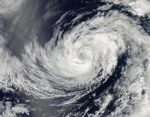
NASA sees a weaker Tropical Storm Douglas

NASA's Aqua satellite captured a picture of Tropical Storm Douglas as it began moving into cooler waters in the Eastern Pacific Ocean. Those cooler waters, coupled with drier air are expected to bring about the storm's demise, according to the National Hurricane Center.
A visible image of Tropical Storm Douglas was taken by the Moderate Resolution Imaging Spectroradiometer or MODIS instrument aboard NASA's Aqua satellite on July 1 at 21:20 UTC (5:20 p.m. EDT). The thickest band of thunderstorms appeared over the southern semi-circle of the weakening storm while bands of thunderstorms in the northwestern quadrant appeared thinner.
At 5 a.m. EDT on July 2, satellite data showed a burst of deep convection (rising air that forms thunderstorms that make up a tropical cyclone) in the northern semicircle of Tropical Storm Douglas, despite being over cooler waters. Sea surface temperatures generally need to be around 80F (26.6C) to maintain thunderstorm development in a tropical cyclone. Douglas has now entered cooler waters.
On July 2 at 5 a.m. EDT (09:00 UTC) the center of Tropical Storm Douglas was located near latitude 19.6 north and longitude 116.0 west, about 455 miles (730 km) west-southwest of the southern tip of Baja California, Mexico. Douglas is moving toward the northwest near 3 mph (6 kph) and a slow motion toward the northwest or north-northwest is expected for the next couple of days as the storm weakens. Maximum sustained winds are near 45 mph (75 kph).
Forecaster Stewart at the National Hurricane Center noted today that the water ahead Douglas will become increasingly colder while the surrounding air mass will become drier and more stable, sapping the ability for thunderstorm development. NHC expects gradual weakening over the next day and Douglas is expected to become a remnant low by 48 hours, if not sooner.
Provided by NASA's Goddard Space Flight Center


